Home
Weather New York
WeatherRadar
RainRadar
TemperatureRadar
WindRadar
LightningRadar
Weather News
Editor's Pick
Discover the app
Weather widget
Contact us
Apps
Career
    Home / Weather News /

    Gulf storm heads to Florida, SoCal's rains
10:00 AM
March 10, 2025

Breakfast Brief
Gulf storm heads to Florida, SoCal's rains
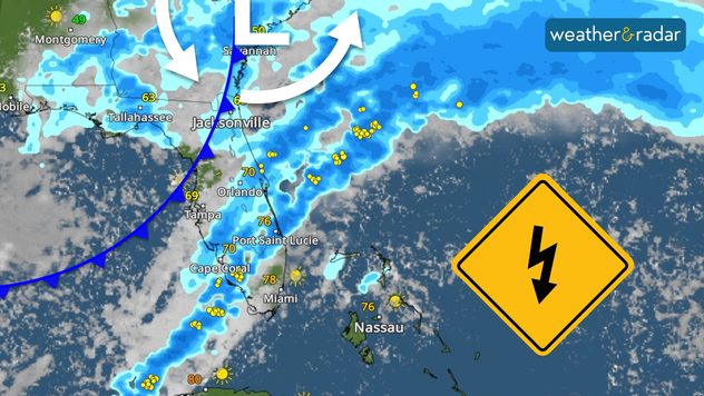
The week starts mostly quietly in most of the United States. The storm bordering the Gulf Coast will impact Florida as another system moves over Southern California. The Breakfast Brief is published daily, Monday through Friday, at 5:00 a.m. Eastern time.

A low-pressure system that brought rounds of rain and thunderstorms over Texas and through the Gulf Coast states on Sunday will affect the Deep South, Georgia, and Florida on Monday. This low-pressure system has a cold front that will sweep through Florida and bring the chance for storms. The cold front will bring isolated storms to South Florida by Monday afternoon. This is much-needed rain as the drought has worsened in the last couple of weeks.

1/2

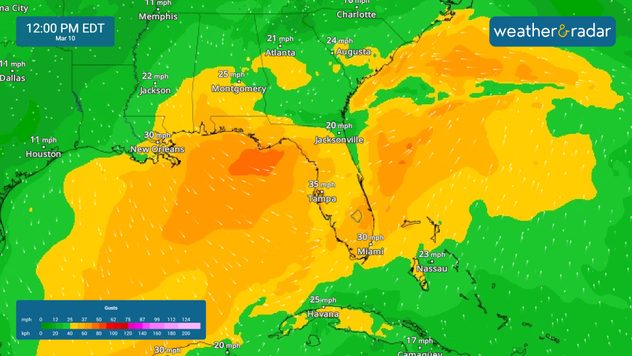
In addition to the storms, this low-pressure system will bring strong winds over the Peninsula, making the seas dangerous and producing strong gusts. Make sure to secure any loose objects and stay away from the water.

There will be a warming trend over the Central Plains as the winds will be from the South in response to a centered high-pressure system. Temperatures around the Northern Plains will be about 30 degrees above average, with highs reaching the low-60s on Monday. On Tuesday, this warmth will expand and move over the Great Lakes and Ohio Valley.

Across Southern California, a low-pressure system is moving onshore, bringing showers during the late afternoon and evening hours. This system will also bring some storm gusts, especially along the coast. Highs will stay between the mid-50s and low-60s.

News we're covering

  • Florida's storms & cooldown?
  • Strong winds for coastal Carolinas
  • The warming trend for the Plains and eastward

Things you might have missed

Hawaii eruptionread more
Spring fever buildsread more

App news & updates:

Do you know the difference between the actual temperatures and the feels-like temperatures? Another feature we offer in our app. Find out how here.

Irene Sans
More on the topic
High pressure & extreme heat. Why & how does it work?. . . Sunday, July 12, 2026
Sunday, July 12, 2026

Why & how does it work?

High pressure & extreme heat
Super Typhoon Bavi threatens Taiwan. 155 mph winds. . Weather Videos. Wednesday, July 8, 2026
The image shows an intense tropical cyclone over the western Pacific, east of Taiwan and the Philippines. The centre of the system is depicted as a light purple and white vortex with a clearly visible eye, surrounded by a ring of red and orange areas indicating the strongest wind speeds. A white arrow marks the typhoon’s predicted track towards the north-west, in the direction of Taiwan. To the west of the storm lie the Philippines, with the cities of Manila and Cebu; to the north of these lies Taiwan, with Taipei. Further west, the Chinese coast, including Hong Kong, and parts of Vietnam can be seen. The coloured wind map shows predominantly green areas outside the storm’s core, indicating significantly weaker winds. White streamlines illustrate the typhoon’s anti-clockwise circulation in the Northern Hemisphere. The highest wind speeds are concentrated around the eye of the cyclone.
Weather VideosWednesday, July 8, 2026

155 mph winds

Super Typhoon Bavi threatens Taiwan
Waterspouts possible, what are they?. They can be dangerous. . . Saturday, July 11, 2026
Waterspouts weatherradar.
Saturday, July 11, 2026

They can be dangerous

Waterspouts possible, what are they?
All weather news
This might also interest you
Temps 15-degrees below average. Big cold front. . . Wednesday, July 22, 2026
Wednesday, July 22, 2026

Big cold front

Temps 15-degrees below average
Multi-Day flood threat for Mid-Atlantic. Stalled front. . . Wednesday, July 22, 2026
Wednesday, July 22, 2026

Stalled front

Multi-Day flood threat for Mid-Atlantic
Intense rain for the Northeast. Flooding possible. . . Tuesday, July 28, 2026
Tuesday, July 28, 2026

Flooding possible

Intense rain for the Northeast
All articles
Weather & Radar

Weather & Radar is also available on

Google Play StoreApp Store

Company

Contact us Privacy policy Legal info Accessibility statement

Services

Uploader

Socials

instagramfacebookthreadslinkList