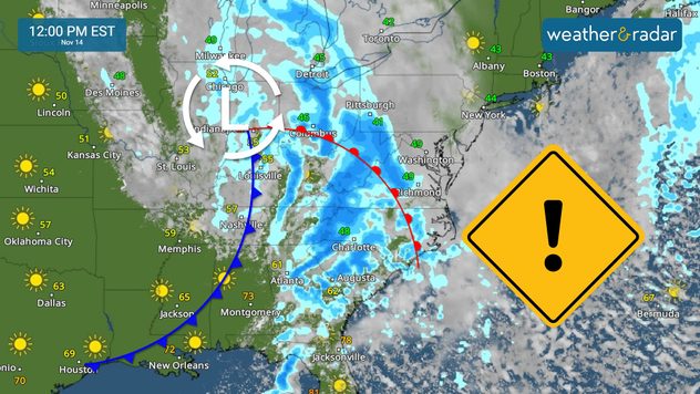
Home / Editor's Pick /

Heavy rains for East Coast, prolific tropics

10:00 AM
November 14, 2024

Breakfast Brief
Heavy rains for East Coast, prolific tropics

Two different systems will impact both coasts. On Thursday, heavy rains and mountain snow will fall, affecting the commute to and from work. The Breakfast Brief is published every Monday through Friday at 5 a.m. ET.

A large rain system moves east, and the early morning will be stormy for the lower Ohio Valley through the Florida Panhandle. Scattered showers will arrive in the afternoon for New York City as the low pressure moves toward the Northeast. Cooler air could trigger a few flurries as some moisture moves over inland New Hampshire and Maine, where there could also be mixed precipitation and ice accumulating by early Friday morning.

This incoming front will push much cooler and drier air across Florida, but before all the heaviest rain will fall over the Mid-Atlantic through the Southeast.

The southern portion of the front will lose its moisture, but plenty of dry air will move south over Florida throughout the day on Friday. There is only a small chance of showers over the northern portion of the Peninsula, but it is mostly dry from Central Florida and southward. Much drier and cooler conditions for the weekend for the Sunshine State.

For the west, specifically the Pacific Northwest, that system entered on Wednesday, staying close enough to continue to provoke heavy rains and snow from the Pacific coast through the northern Rockies. This system will linger around the same area, holding back all the rain and winter precipitation over the same region until Saturday. Still, once it moves, another system arrives to continue the wet pattern.

November 14, 1969

As a cold front moving over Florida, there was Apollo 12 waiting to launch from Kennedy Space Center. It launched, but about 37 seconds after launch, the rocket was hit by lightning, and then again 52 seconds after launch. The astronauts had not idea waht happened. The mission was rapidly saved by switching to the auxiliary power supply which resolved the data relay problem. 

Tropical update:

The tropics continue to be prolific this season. Tropical Depression 19 formed, and is moving very slowly over the western Caribbean. It should become Tropical Storm Sara over the weekend. It will likely become a hurricane as it meanders over the Caribbean over the weekend. Weather conditions, such as low wind shear and warm sea surface temperatures, will sustain this system for intensification.

Honduras should prepare to receive around 20 inches of rain through the next 2 to 3 days as the system crawls near the country. It is forecast to push through the Yucatan Peninsula early next week and then it should pick up speed as a front will likely push Sara toward Florida. Please stay tuned and informed.

News we are covering today:

  • Heavy rains for the East
  • Caribbean storm
  • Incoming heavy precipitation continues for the Northwest

Did you miss these?

Useful tips when driving in the rainread more
Dry vegetation, low humidity and windsread more

App news & updates:

Our WeatherRadar goes with you wherever you go in the world. You can track storms and showers and see how a storm system moves up to 4 days in advance. This is all free and in your hands, always accessible. The WeatherRadar our most popular tool

Irene Sans
More on the topic
Perseid meteor shower and airglow above the Seemannskirche church in Prerow.
Sunday, August 10, 2025

Perseids flying overhead

Spot a meteor shower before its peak
Dark sky full of stars. Several shooting stars fly in different directions – typical of a meteor shower.
Attention not translate yet!Saturday, August 16, 2025

Night sky photos

Night sky in the spotlight
Split image: on the left, a bright flash of lightning in the night sky; on the right, a map of the USA with a dense distribution of lightning symbols in the south and west.
Sunday, August 3, 2025

New world record

Mega flash in the USA
All weather news
This might also interest you
Hurricane Erin will move near the East Coast throughout the week.
Monday, August 18, 2025

Big waves, rip currents

Hurricane Erin brings coastal problems
Erin's threat
Tuesday, August 19, 2025

Latest hurricane update

Erin to slide by Hatteras
Tuesday, August 19, 2025

Daily Briefing

Latest on Erin, Plains heat
All articles
Weather & Radar

www.weatherandradar.com

instagramfacebookthreadsContact uslinkList
Privacy policy | Legal info | Accessibility statement