Home
Weather New York
WeatherRadar
RainRadar
TemperatureRadar
WindRadar
LightningRadar
Weather News
Editor's Pick
Discover the app
Weather widget
Contact us
Apps
Career
    Home / Weather News /

    Heavy snow accumulates: Blizzard strike Northeast

04:03 PM
February 23, 2026

Heavy snow accumulates
Blizzard strikes Northeast

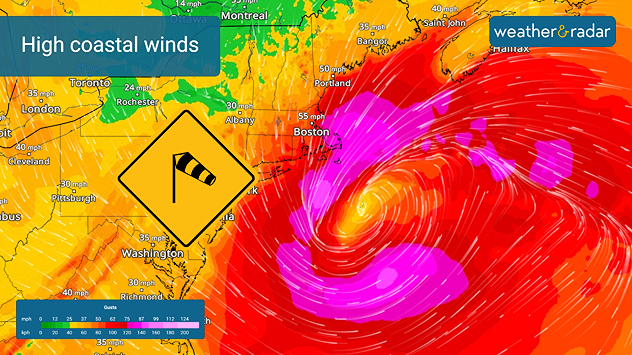
The one-two combination of heavy wet snow and winds gusting in excess of 35 mph is producing blizzard conditions along the coastal Northeast.

The WeatherRadar showed snow started on Sunday afternoon. It will continue through this afternoon along the I-95 corridor from Philadelphia to Boston. More than a foot of snow has already fallen in many places with more than 2 feet reported across parts of southern New England and in the greater New York City area and Long Island.

Coastal areas of New England could see wind gusts in excess of 55 mph through today.

The nor'easter producing the heavy snow is also producing extreme winds too. The WindRadar is showing wind gusts ranging from 35 mph to 65 mph, lasting well into this afternoon. Even higher gusts are occurring along the immediate New England coasts, causing blowing snow and white-out conditions. Blizzard warnings remain in effect through this afternoon.

The high winds have knocked out power to more than a quarter-million customers in Massachusetts, with more than 125,000 customers without power in New Jersey. Additional power outages are possible today.

James West
More on the topic
Super Typhoon Near the Philippines. Gusts up to 155. . . Tuesday, June 23, 2026
Tuesday, June 23, 2026

Gusts up to 155

Super Typhoon Near the Philippines
Rip currents & safety tips. As more head to the coast. . . Sunday, July 5, 2026
rip current
Sunday, July 5, 2026

As more head to the coast

Rip currents & safety tips
Super Typhoon Bavi threatens Taiwan. 155 mph winds. . Weather Videos. Wednesday, July 8, 2026
The image shows an intense tropical cyclone over the western Pacific, east of Taiwan and the Philippines. The centre of the system is depicted as a light purple and white vortex with a clearly visible eye, surrounded by a ring of red and orange areas indicating the strongest wind speeds. A white arrow marks the typhoon’s predicted track towards the north-west, in the direction of Taiwan. To the west of the storm lie the Philippines, with the cities of Manila and Cebu; to the north of these lies Taiwan, with Taipei. Further west, the Chinese coast, including Hong Kong, and parts of Vietnam can be seen. The coloured wind map shows predominantly green areas outside the storm’s core, indicating significantly weaker winds. White streamlines illustrate the typhoon’s anti-clockwise circulation in the Northern Hemisphere. The highest wind speeds are concentrated around the eye of the cyclone.
Weather VideosWednesday, July 8, 2026

155 mph winds

Super Typhoon Bavi threatens Taiwan
All weather news
This might also interest you
Fireworks and Air Quality. Smoke and pollution. . . Saturday, July 4, 2026
Saturday, July 4, 2026

Smoke and pollution

Fireworks and Air Quality
Understanding the feels like temperature. Advanced heat measurement. . . Friday, July 3, 2026
feels like temperature
Friday, July 3, 2026

Advanced heat measurement

Understanding the feels like temperature
Lightning season in full bloom. Staying safe this summer. . . Monday, July 6, 2026
Monday, July 6, 2026

Staying safe this summer

Lightning season in full bloom
All articles
Weather & Radar

Weather & Radar is also available on

Google Play StoreApp Store

Company

Contact us Privacy policy Legal info Accessibility statement

Services

Uploader

Socials

instagramfacebookthreadslinkList