Home
Weather New York
WeatherRadar
RainRadar
TemperatureRadar
WindRadar
LightningRadar
Weather News
Editor's Pick
Discover the app
Weather widget
Contact us
Apps
Career
    Home / Editor's Pick /

    Hilary targets California: Impacts, threats & timing to California & surroundings

01:30 AM
August 20, 2023

Hilary targets California
Impacts, threats & timing

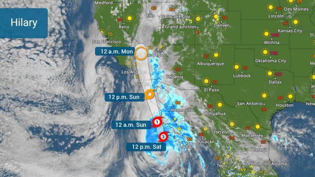
Hilary has started to make the turn northward and on Saturday afternoon it is still a major category 3 hurricane. Southern California, southwestern Arizona, and the south and western regions of Nevada prepare for torrential rains that could bring dangerous floods and landslides.

Hilary's track issued on Saturday at 3pm MT

The good news is that Hilary will continue to move northward and is about to enter a much cooler swath of Pacific waters, this will cut down the intensity rapidly during the next 12 to 24 hours. But please be aware that Hilary is a massive storm and although intensity will be diminishing, hurricane categories only refer to wind speeds. Hilary will gain forward speed as it loses strength, still dropping lots of rain for SoCal and parts of Nevada.

The biggest threat for Southern California is the torrential rains that much of the terrain cannot drain safely or fast enough. After all, the highest rainfall is forecast to affect the interior areas of southern California, much of it a desert. Mountains are in for large amounts of rain, that could cause landslides. Residents near the Peninsular Ranges and the eastern portion of the Transverse Mountains should be especially aware.

Hazards will be highly dependent on the location and the track Hilary's center takes.

The central Imperial northward through the Inland Empire is in for very large quantities of rainfall that could reach 10 inches in some isolated spots. The highest rainfall will be falling through Sunday night. Widespread amounts across the Empires will range between 3 and 6 inches.

Tropical terminology to knowread more

San Diego and Orange Counties are not expected to receive such high amounts but, rest assured that there would be some dangerous floods. Rainfall will range between 2-4 inches along the coast extending through Los Angeles.

Atlantic: Depression #6 & 4 wavesread more

What worries meteorologists the most?

Rainfall, tornadoes, winds, and surf.

Excessive rainfall will not only cause dangerous floods, especially across those areas where the drainage is not the best, due to natural conditions (like the desert) but also across those areas with heavy populations and lots of concrete. Please remember, turn around, and don’t drown. Riverbeds are especially dangerous, so if you live in southern California or areas anywhere in the Southwestern U.S. pay close attention. If you are in an area forecast for excessive rainfall of downslope a river near mountains, you should consider going to higher grounds and staying there through Monday.

How does a hurricane form and its risksread more

Winds will be the strongest over elevated terrain. The mountains will experience the strongest gusts and be confined over inland areas of the forecast track.

Tornadoes are also a possibility, especially among those rainbands moving inland over parts of the lower Colorado River Valley, and Imperial Valley regions. Think to the right of where the center of the storm moves. Some tornadic storms will travel in the storms embedded in rainbands.

Sunday through much of Monday won’t be the best days to be in the water. Even after the rain tapers off in Southern California, there will be large swells that will bring life-threatening surf and rip currents.

Make sure to have your alerts turned on. Have at least 3 ways of receiving weather alerts, even as Hilary downgrades. Our team of meteorologists will be working throughout the weekend to keep you posted about the latest changes on track and impacts. Our weather reporter has been deployed to cover what's happening across Southern California.

**This same information can be seen in Spanish, written by our bilingual meteorologists if your phone is set to Spanish and using our app too. Tell your family and friends that only speak Spanish so that they can also be informed and stay safe, please.**

Irene Sans
More on the topic
Record ocean heat halting hurricanes. Strong El Niño influence. . . Sunday, September 13, 2026
A weather map shows a calm Atlantic Ocean with no hurricanes, alongside a picture of the sea.
Sunday, September 13, 2026

Strong El Niño influence

Record ocean heat halting hurricanes
Hurricane Polo remains dangerous. Active Pacific. . . Thursday, September 24, 2026
Thursday, September 24, 2026

Active Pacific

Hurricane Polo remains dangerous
Hawaii's second 2026 hurricane impact. Hurricane Lowell. . . Tuesday, September 8, 2026
Tuesday, September 8, 2026

Hurricane Lowell

Hawaii's second 2026 hurricane impact
All weather news
This might also interest you
Autumn cold front arrives. October cooldown spreads. . . Friday, October 2, 2026
Cold front brings cooler temperatures.
Friday, October 2, 2026

October cooldown spreads

Autumn cold front arrives
1,800 miles of rain. From Texas to Michigan. . . Thursday, October 1, 2026
Thursday, October 1, 2026

From Texas to Michigan

1,800 miles of rain
Autumn foliage: weather's impact. Leaf-peeping season!. . . Sunday, October 4, 2026
Cool nights can help intensify autumn foliage color!
Sunday, October 4, 2026

Leaf-peeping season!

Autumn foliage: weather's impact
All articles
Weather & Radar

Weather & Radar is also available on

Google Play StoreApp Store

Company

Contact us Privacy policy Legal info Accessibility statement

Services

Uploader

Socials

instagramfacebookthreadslinkList