Home
Weather New York
WeatherRadar
RainRadar
TemperatureRadar
WindRadar
LightningRadar
Weather News
Editor's Pick
Discover the app
Weather widget
Contact us
Apps
Career
    Home / Weather News /

    Historic records to fall: Southwest heat wave builds

09:00 PM
March 16, 2026

Historic records to fall
Heat wave hits Southwest

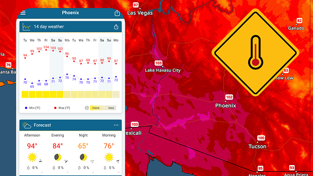
An unprecedent early-season heat wave is occuring across the Southwest and southern California, with some of the earliest triple-digits readings likely setting new records.

An expanding upper-level ridge is developing across the West with high pressure producing abundant sun-filled days and warm nights.

Each day this week will become progressively hotter, with interior southern California, the lower Colorado River basin and southern Arizona, easily climbing into the triple digits Wednesday. This hot weather will last into the weekend.

Although these areas are no strangers to extreme heat, this heat wave is early. Phoenix doesn't see its first triple-digit day until early May and several locations across southern California could set new all-time monthly high temperature records later this week and this weekend as highs climb into the 105 to 110 degree range.

Phoenix

Mo
90
106
Tu
88
105
We
87
107
Th
91
110
Fr
94
111
Sa
93
113
Su
95
117
Mo
95
116
Tu
94
109
We
91
108
Th
90
108
Fr
89
108
Sa
92
113
Su
93
115
Max (°F)
Min (°F)
moreless

Remember, drink plenty of water to stay hydrated as the temperatures rise, but do not try to cool off in waterways, lakes and reservoirs yet. Water temperatures are still cold from the winter and hyperthermia could occur rapidly.

James West
More on the topic
Europe: Warmest June on record. Warm waters too. . . Friday, July 10, 2026
The record-breaking heatwave in June has made climate history in Western Europe.
Friday, July 10, 2026

Warm waters too

Europe: Warmest June on record
Super Typhoon Bavi threatens Taiwan. 155 mph winds. . Weather Videos. Wednesday, July 8, 2026
The image shows an intense tropical cyclone over the western Pacific, east of Taiwan and the Philippines. The centre of the system is depicted as a light purple and white vortex with a clearly visible eye, surrounded by a ring of red and orange areas indicating the strongest wind speeds. A white arrow marks the typhoon’s predicted track towards the north-west, in the direction of Taiwan. To the west of the storm lie the Philippines, with the cities of Manila and Cebu; to the north of these lies Taiwan, with Taipei. Further west, the Chinese coast, including Hong Kong, and parts of Vietnam can be seen. The coloured wind map shows predominantly green areas outside the storm’s core, indicating significantly weaker winds. White streamlines illustrate the typhoon’s anti-clockwise circulation in the Northern Hemisphere. The highest wind speeds are concentrated around the eye of the cyclone.
Weather VideosWednesday, July 8, 2026

155 mph winds

Super Typhoon Bavi threatens Taiwan
How does fog form?. Multiple ways. . . Saturday, July 11, 2026
Saturday, July 11, 2026

Multiple ways

How does fog form?
All weather news
This might also interest you
Poor air quality to span 1.2K+ miles. Canadian wildfires. . . Wednesday, July 15, 2026
Wednesday, July 15, 2026

Canadian wildfires

Poor air quality to span 1.2K+ miles
Wildfire smoke travels 1K+ miles. Canada to Mid-Atlantic. . . Tuesday, July 14, 2026
Tuesday, July 14, 2026

Canada to Mid-Atlantic

Wildfire smoke travels 1K+ miles
Dangerous air quality continues. Canada wildfires smoke. . . Friday, July 17, 2026
Smoky Philadelphia
Friday, July 17, 2026

Canada wildfires smoke

Dangerous air quality continues
All articles
Weather & Radar

Weather & Radar is also available on

Google Play StoreApp Store

Company

Contact us Privacy policy Legal info Accessibility statement

Services

Uploader

Socials

instagramfacebookthreadslinkList