Home
Weather New York
WeatherRadar
RainRadar
TemperatureRadar
WindRadar
LightningRadar
Weather News
Editor's Pick
Discover the app
Weather widget
Contact us
Apps
Career
    Home / Editor's Pick /

    Hurricane parade in the Pacific – cyclones stay out at sea

05:00 PM
September 1, 2026

Karina is very strong
Hurricane parade in the Pacific

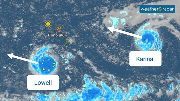
Things are hotting up in the eastern Pacific. Two tropical storms are already swirling over the warm ocean, and one of them has now gained considerable strength. Karina is already a Category 4 hurricane.

Lowell is also set to reach hurricane strength. As things stand, both storms will remain over the open Pacific and pose no direct threat to either Mexico or Hawaii.

Satellite weather map near Hawaii showing tropical systems Lowell and Karina with blue rain bands, marked centres, and arrows indicating western movement.
Hawaii is not in their path: Lowell and Karina are expected to pass by the islands, as our WeatherRadar shows.

And there’s already more on the way: a tropical depression has formed off the coast of Mexico. It is likely to strengthen into a tropical storm soon and will then be named Maria.

Maria could also develop into a hurricane by Friday. That would mean we would have three hurricanes in a row over the eastern Pacific – although, as things stand, they pose no direct threat to land.

Did you know?

El Niño often brings warmer water and more favorable wind conditions to the eastern Pacific. This makes it easier for hurricanes to form and intensify.

Weather & Radar USA editorial team
More on the topic
All about nocturnal severe weather. Risks & preparedness. . . Saturday, August 22, 2026
Saturday, August 22, 2026

Risks & preparedness

All about nocturnal severe weather
What are weather fronts?. Weather explained. . . Sunday, August 23, 2026
Image of a temperature radar showing a clear distinction between a warm and cold air mass separated by a cold front.
Sunday, August 23, 2026

Weather explained

What are weather fronts?
Super Typhoon Bavi threatens Taiwan. 155 mph winds. . Weather Videos. Wednesday, July 8, 2026
The image shows an intense tropical cyclone over the western Pacific, east of Taiwan and the Philippines. The centre of the system is depicted as a light purple and white vortex with a clearly visible eye, surrounded by a ring of red and orange areas indicating the strongest wind speeds. A white arrow marks the typhoon’s predicted track towards the north-west, in the direction of Taiwan. To the west of the storm lie the Philippines, with the cities of Manila and Cebu; to the north of these lies Taiwan, with Taipei. Further west, the Chinese coast, including Hong Kong, and parts of Vietnam can be seen. The coloured wind map shows predominantly green areas outside the storm’s core, indicating significantly weaker winds. White streamlines illustrate the typhoon’s anti-clockwise circulation in the Northern Hemisphere. The highest wind speeds are concentrated around the eye of the cyclone.
Weather VideosWednesday, July 8, 2026

155 mph winds

Super Typhoon Bavi threatens Taiwan
All weather news
This might also interest you
100 days of at least 100°F. Phoenix. . . Wednesday, August 26, 2026
Wednesday, August 26, 2026

Phoenix

100 days of at least 100°F
Atlantic springs into activity. Tropical Storm Dolly. . . Thursday, August 27, 2026
Thursday, August 27, 2026

Tropical Storm Dolly

Atlantic springs into activity
Be ready for tropical activity. Tips & tools. . . Saturday, August 29, 2026
Track hurricanes with the WeatherRadar
Saturday, August 29, 2026

Tips & tools

Be ready for tropical activity
All articles
Weather & Radar

Weather & Radar is also available on

Google Play StoreApp Store

Company

Contact us Privacy policy Legal info Accessibility statement

Services

Uploader

Socials

instagramfacebookthreadslinkList