Home
Weather New York
WeatherRadar
RainRadar
TemperatureRadar
WindRadar
LightningRadar
Weather News
Editor's Pick
Discover the app
Weather widget
Contact us
Apps
Career
    Home / Editor's Pick /

    Icy beauty - The science behind rime ice

08:00 PM
January 4, 2026

Icy beauty
The science behind rime ice

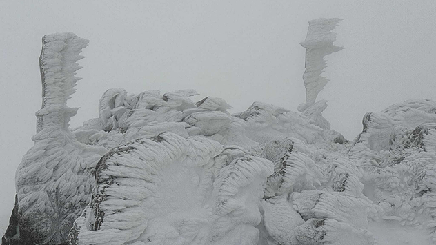
Once winter's chill settles in, rime ice can form due to low clouds or fog, especially in high elevations. All you need are surface temperatures below freezing. So how does it work?

Rime ice is a type of frozen precipitation that forms when supercooled liquid droplets freeze onto surfaces. The droplets usually come from fog or low-lying clouds, and they freeze instantly upon contact with a surface that is at or below freezing temperature. Have you seen any freezing temperatures on our TemperatureRadar?

1/2
Rime ice on top of Mount Reixa in northern Italy on December 10, 2024. Images by Andrea Ferrando.

When the ice forms, it can look fuzzy or feathery, just like it did in Italy's Ligurian Apennines on Monte Reixa in mid-December 2024. Closer to home, Mount Washington in New Hampshire often sees this weather phenomenon due to the mountain's elevation of over 6,000 feet and, therefore, very cold temperatures at the mountaintop.

The feathery, fuzzy texture of rime ice is caused by the way the supercooled droplets freeze. As the droplets freeze, they release heat, which causes the surrounding air to expand rapidly. This expansion causes the droplets to break apart and form a mist, which then freezes to form feathery crystals of rime ice.

Did you know?

Use the handy Weather & Radar app to know when you could experience freezing fog - hopefully from the comfort of your own home. Surface temperatures, like on your car, have to be at or below freezing. For fog to form, we want the dewpoint as close to the outside temperature as possible. Find the dewpoint information in your hourly forecast at the top of the app!

You can look for the wintertime fog or low clouds on the WeatherRadar. They show up rather thick on the satellite and can often be a problem for air travel when the aircraft surface is at or below freezing. Remember the last time you had to wait for the air traffic crew to de-ice the plane? Now you know part of why they're taking these precautions!

Mary Mays
More on the topic
Meteorological summer is here!. Bye, spring!. . . Monday, June 1, 2026
Monday, June 1, 2026

Bye, spring!

Meteorological summer is here!
The only Blue Moon of the year rises. May astronomy outlook. . . Saturday, May 2, 2026
Saturday, May 2, 2026

May astronomy outlook

The only Blue Moon of the year rises
High pressure & extreme heat. Why & how does it work?. . . Sunday, June 28, 2026
Sunday, June 28, 2026

Why & how does it work?

High pressure & extreme heat
All weather news
This might also interest you
Understanding the feels like temperature. Advanced heat measurement. . . Friday, July 3, 2026
feels like temperature
Friday, July 3, 2026

Advanced heat measurement

Understanding the feels like temperature
Saharan dust to reach Florida. Dry period expected. . . Tuesday, July 7, 2026
Saharan dust seen on the satllite image (right) moving westward toward Florida. Air quality impacts are expected.
Tuesday, July 7, 2026

Dry period expected

Saharan dust to reach Florida
Lightning season in full bloom. Staying safe this summer. . . Monday, July 6, 2026
Monday, July 6, 2026

Staying safe this summer

Lightning season in full bloom
All articles
Weather & Radar

Weather & Radar is also available on

Google Play StoreApp Store

Company

Contact us Privacy policy Legal info Accessibility statement

Services

Uploader

Socials

instagramfacebookthreadslinkList