Home
Weather New York
WeatherRadar
RainRadar
TemperatureRadar
WindRadar
LightningRadar
Weather News
Editor's Pick
Discover the app
Weather widget
Contact us
Apps
Career
    Home / Weather News /

    Last month of hurricane season: Will we see more storms?

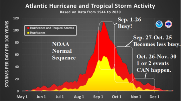
Last month of the season
How common are November hurricanes?

November marks the last month of the Atlantic Hurricane Season, with the official end coming on Nov. 30. So where do storms typically form in the last month of the season?

In terms of climatology, storm development in November tends to favor the Caribbean, southwestern Atlantic and central Atlantic Ocean. While U.S. hurricane landfalls in November are rare, they do occur. Four hurricanes have made landfall in the U.S. in November, the most recent being Hurricane Nicole on Nov. 10, 2022. Nicole made landfall near Vero Beach, Fla., as a Category 1 storm.

Hurricane Kate made landfall near Mexico Beach, Fla., as a Category 2 storm with sustained winds of 100 mph on Nov. 22, 1985. Kate was the strongest storm to make a U.S. landfall in November.

How to use our hurricane alertsread more

The other two hurricanes to make landfall in November were an unnamed South Florida Category 2 hurricane on Nov. 4, 1935, and the "Expedition Hurricane" in eastern North Carolina (Cat. 1) on Nov. 2, 1861.

Weather & Radar's expert meteorologists will have the latest tropical updates through the end of the season. Check out our Breakfast Brief in the mornings for the latest changes to the forecast.

Mary Mays
This might also interest you
Super Typhoon Bavi threatens Taiwan. 155 mph winds. . Weather Videos. Wednesday, July 8, 2026
The image shows an intense tropical cyclone over the western Pacific, east of Taiwan and the Philippines. The centre of the system is depicted as a light purple and white vortex with a clearly visible eye, surrounded by a ring of red and orange areas indicating the strongest wind speeds. A white arrow marks the typhoon’s predicted track towards the north-west, in the direction of Taiwan. To the west of the storm lie the Philippines, with the cities of Manila and Cebu; to the north of these lies Taiwan, with Taipei. Further west, the Chinese coast, including Hong Kong, and parts of Vietnam can be seen. The coloured wind map shows predominantly green areas outside the storm’s core, indicating significantly weaker winds. White streamlines illustrate the typhoon’s anti-clockwise circulation in the Northern Hemisphere. The highest wind speeds are concentrated around the eye of the cyclone.
Weather VideosWednesday, July 8, 2026

155 mph winds

Super Typhoon Bavi threatens Taiwan
Fireworks and Air Quality. Smoke and pollution. . . Saturday, July 4, 2026
Saturday, July 4, 2026

Smoke and pollution

Fireworks and Air Quality
Turning hot this weekend. Brutal temps across West. . . Friday, July 10, 2026
Saturday & Sunday's highs
Friday, July 10, 2026

Brutal temps across West

Turning hot this weekend
All articles
Weather & Radar

Weather & Radar is also available on

Google Play StoreApp Store

Company

Contact us Privacy policy Legal info Accessibility statement

Services

Uploader

Socials

instagramfacebookthreadslinkList