Home
Weather New York
WeatherRadar
RainRadar
TemperatureRadar
WindRadar
LightningRadar
Weather News
Editor's Pick
Discover the app
Weather widget
Contact us
Apps
Career
    Home / Editor's Pick /

    Meteorological Winter is here

08:42 PM
December 2, 2025

What to expect
Meteorological Winter is here

El invierno meteorológico comprende los meses más fríos del año en España.
© Lilya / Adobe Stock

December 1st marked the official start of meteorological winter. It starts earlier than astronomical winter, which begins on December 21st, to make processing climate data much simpler.

December, January and February make up meteorological winter, the coldest time of year on average in the country. Temperatures drop, and there are snowy days in many places.

Check out the WeatherRadarread more

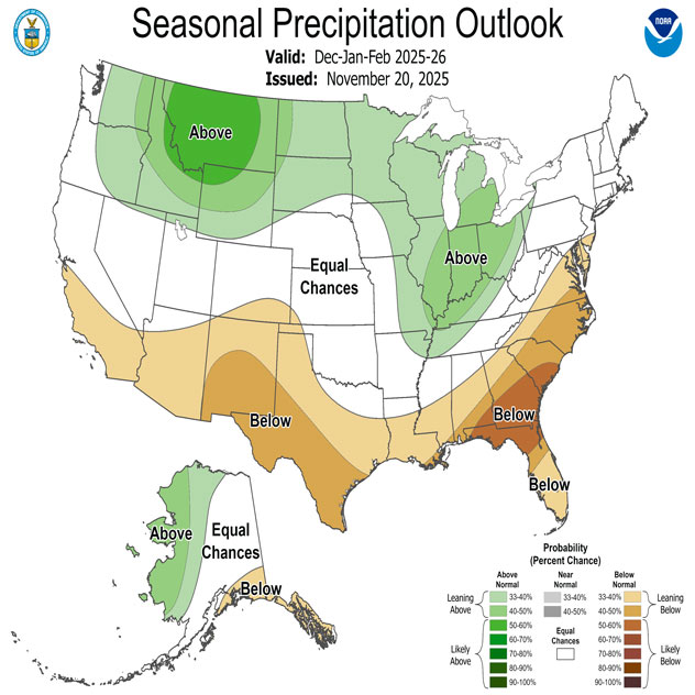
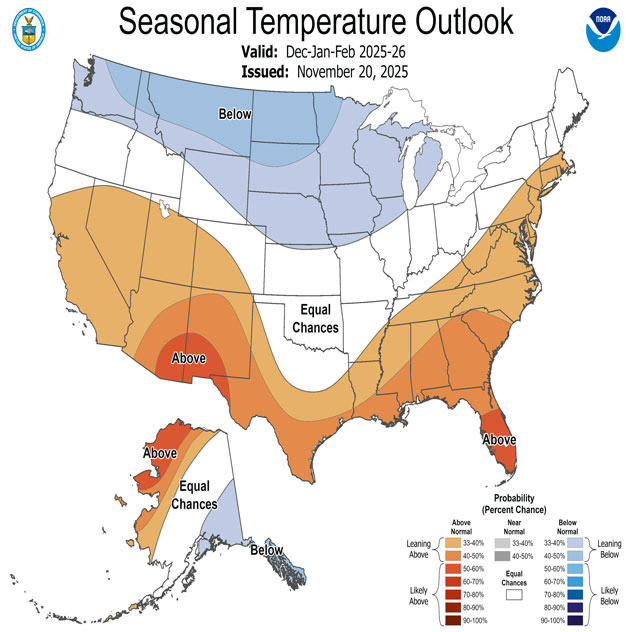
Seasonal weather models allow us to predict how the coming months might unfold. This winter, warmer and drier-than-normal weather is forecast for much of the southern half of the country, with above-average rainfall and cooler-than-average temperatures for this time of year.

This pattern is typical when the La Niña phenomenon is present during the winter. La Niña has been officially declared by NOAA and has a 61 percent chance of lasting through the winter, until March 2026.

1/2

Keep in mind that fronts will occasionally pass through the south, triggering storms that could even be severe, depending on the conditions, as well as outbreaks of freezing air. It's a good idea to check the daily weather forecast so you can stay informed about any potential weather changes.

Turn on your Weather Alertsread more

Mary Mays
More on the topic
The best views of Wednesday's eclipse. Europe's sky show. . . Thursday, August 13, 2026
Solar eclipse: The sun obscured between wind turbines in Sardinia
Thursday, August 13, 2026

Europe's sky show

The best views of Wednesday's eclipse
Super Typhoon Bavi threatens Taiwan. 155 mph winds. . Weather Videos. Wednesday, July 8, 2026
The image shows an intense tropical cyclone over the western Pacific, east of Taiwan and the Philippines. The centre of the system is depicted as a light purple and white vortex with a clearly visible eye, surrounded by a ring of red and orange areas indicating the strongest wind speeds. A white arrow marks the typhoon’s predicted track towards the north-west, in the direction of Taiwan. To the west of the storm lie the Philippines, with the cities of Manila and Cebu; to the north of these lies Taiwan, with Taipei. Further west, the Chinese coast, including Hong Kong, and parts of Vietnam can be seen. The coloured wind map shows predominantly green areas outside the storm’s core, indicating significantly weaker winds. White streamlines illustrate the typhoon’s anti-clockwise circulation in the Northern Hemisphere. The highest wind speeds are concentrated around the eye of the cyclone.
Weather VideosWednesday, July 8, 2026

155 mph winds

Super Typhoon Bavi threatens Taiwan
Super Typhoon Near the Philippines. Gusts up to 155. . . Tuesday, June 23, 2026
Tuesday, June 23, 2026

Gusts up to 155

Super Typhoon Near the Philippines
All weather news
This might also interest you
Be ready for tropical activity. Tips & tools. . . Saturday, August 8, 2026
Track hurricanes with the WeatherRadar
Saturday, August 8, 2026

Tips & tools

Be ready for tropical activity
When severe storms strike.... You can be ready. . . Monday, August 10, 2026
Monday, August 10, 2026

You can be ready

When severe storms strike...
Watch storm clusters interact. A busy WeatherRadar. . . Tuesday, August 11, 2026
Tuesday, August 11, 2026

A busy WeatherRadar

Watch storm clusters interact
All articles
Weather & Radar

Weather & Radar is also available on

Google Play StoreApp Store

Company

Contact us Privacy policy Legal info Accessibility statement

Services

Uploader

Socials

instagramfacebookthreadslinkList