Home
Weather New York
WeatherRadar
RainRadar
TemperatureRadar
WindRadar
LightningRadar
Weather News
Editor's Pick
Discover the app
Weather widget
Contact us
Apps
Career
    Home / Weather News /

    Midwestern blizzard, southern tornadoes
03:11 PM
January 12, 2024

Friday's live blog
Midwestern blizzard, southern tornadoes

Live updates on this winter storm are bein brought all day Friday.

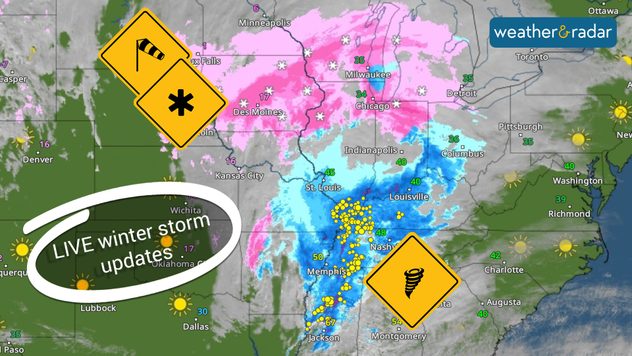
A large winter storm is impacting many from the Midwest south and eastward bringing blizzard conditions, severe storms, and flooding rainfall, just days after the previous winter storm blasted the eastern half. This live blog will be updated throughout the day on Friday to note the latest updates.

4:30 p.m.

Weather & Radar's Jonathan Petramala is in Davenport, Iowa, as blizzard conditions wreak havoc on the roads. Residents of the Quad Cities are encouraged to stay home if possible.

4:00 p.m.

Snow continues to pile up across the Midwest. The Chicago metro has picked up 3-6 inches, while a few communities in Iowa and Wisconsin have snow totals already at or more than a foot.

3:00 p.m.

The Storm Prediction Center has received 33 filtered reports of wind damage since midnight across southeastern Arkansas, northeastern Louisiana, and into northern Mississippi. With winds still gusting in excess of 50 mph, it's important to tie down loose outdoor items.

2:00 p.m.

Flight cancellations continue to rise at several major airports. There have been more than 400 canceled and nearly 200 delayed flights at Chicago's O'Hare International, with 140 canceled and 26 delayed at Chicago's Midway Airport. M​ore than 300 flights have been canceled or delayed at Denver International and more than 50 at Milwaukee Mitchell International Airport.

12:45 p.m.

Meteorologist Becca Parker will be live on YouTube at 1 p.m. ET, covering the latest on the powerful winter storm. Click the video below to watch.

12:30 p.m.

Snow totals over the last 24 hours vary, with Finland, Minn., which is just off Lake Superior, picking up 17 inches. This event is ongoing, and these totals will continue growing for many communities. So far, the city of Chicago has picked up between 1 and 3 inches of snow, with the northern and western suburbs seeing 3 to 8 inches on the ground.

12:00 p.m.

Road conditions in Iowa continue to deteriorate with parts of I-80's eastbound lane shut down near Victor. Avoid traveling unless it's absolutely necessary.

11:30 a.m.

Power outages are growing as this massive storm continues to impact the eastern half of the U.S. Here are the numbers of customers without power in states impacted by this system.

  • Illinois- 80,710
  • Texas- 50,797
  • Wisconsin- 22,791
  • Arkansas- 19,644
  • Tennessee- 18.020

10:30 a.m.

Winds are gusting up to 55 mph outside of thunderstorms across the South this morning. Keep up with these powerful gusts on the WindRadar.

9:30 a.m.

More than 1,000 flights are grounded nationwide due to treacherous conditions from the blizzard conditions in the Midwest. Chicago O'Hare holds 700 of those grounded flights.

Iowa is also seeing winter storm delays. Many are having snow days this Friday!

Weather & Radar USA editorial team
More on the topic
Record-breaking heatwave in Europe. Hotter than most of U.S.. . . Thursday, June 25, 2026
Thursday, June 25, 2026

Hotter than most of U.S.

Record-breaking heatwave in Europe
Super Typhoon Bavi threatens Taiwan. 155 mph winds. . Weather Videos. Wednesday, July 8, 2026
The image shows an intense tropical cyclone over the western Pacific, east of Taiwan and the Philippines. The centre of the system is depicted as a light purple and white vortex with a clearly visible eye, surrounded by a ring of red and orange areas indicating the strongest wind speeds. A white arrow marks the typhoon’s predicted track towards the north-west, in the direction of Taiwan. To the west of the storm lie the Philippines, with the cities of Manila and Cebu; to the north of these lies Taiwan, with Taipei. Further west, the Chinese coast, including Hong Kong, and parts of Vietnam can be seen. The coloured wind map shows predominantly green areas outside the storm’s core, indicating significantly weaker winds. White streamlines illustrate the typhoon’s anti-clockwise circulation in the Northern Hemisphere. The highest wind speeds are concentrated around the eye of the cyclone.
Weather VideosWednesday, July 8, 2026

155 mph winds

Super Typhoon Bavi threatens Taiwan
Waterspouts possible, what are they?. They can be dangerous. . . Saturday, July 11, 2026
Waterspouts weatherradar.
Saturday, July 11, 2026

They can be dangerous

Waterspouts possible, what are they?
All weather news
This might also interest you
Temps 15-degrees below average. Big cold front. . . Wednesday, July 22, 2026
Wednesday, July 22, 2026

Big cold front

Temps 15-degrees below average
Multi-Day flood threat for Mid-Atlantic. Stalled front. . . Wednesday, July 22, 2026
Wednesday, July 22, 2026

Stalled front

Multi-Day flood threat for Mid-Atlantic
Southwest heat disrupts daily flow. Closures & delays. . . Monday, July 27, 2026
Monday, July 27, 2026

Closures & delays

Southwest heat disrupts daily flow
All articles
Weather & Radar

Weather & Radar is also available on

Google Play StoreApp Store

Company

Contact us Privacy policy Legal info Accessibility statement

Services

Uploader

Socials

instagramfacebookthreadslinkList