Home
Weather New York
WeatherRadar
RainRadar
TemperatureRadar
WindRadar
LightningRadar
Weather News
Editor's Pick
Discover the app
Weather widget
Contact us
Apps
Career
    Home / Editor's Pick /

    Much better end to the week: strong to severe scattered storms

02:28 PM
April 19, 2024

Much better to end week
Strong to severe scattered storms

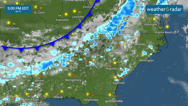
Luckily the active weather week ends on a much better note, and the risk for severe storms —mostly unorganized —will be mainly confined to the Southeast.

The system that has brought severe weather on Thursday exits but a lingering front will continue to fizzle out across the South and Southeast. The tail end of this front will become stationary, draping from Georgia through Texas and attached to the next system that will be traveling over Texas during the weekend, drenching the Lone Star State.

A cold front starts to fizzle out, some scattered strong to severe storms are possible across the South.

For Friday the scattered storms will affect northern Alabama and Georgia northward through the Carolinas and eastern Tennessee. Some of the storms could turn severe, but they will be very isolated.

Supercell storm brought lightning, windread more

Texans will have to keep their umbrellas handy this weekend. The next storm system will be bringing widespread rain starting early Saturday, especially across the northern half of the state. The southern portion will have scattered rains in the morning, but storms quickly will our WeatherRadar during the afternoon.

We will be monitoring this system and the risk of floods across the Midwest and Great Lake area.

Irene Sans
More on the topic
Waterspouts possible, what are they?. They can be dangerous. . . Saturday, July 11, 2026
Waterspouts weatherradar.
Saturday, July 11, 2026

They can be dangerous

Waterspouts possible, what are they?
Rip currents & safety tips. As more head to the coast. . . Sunday, July 5, 2026
rip current
Sunday, July 5, 2026

As more head to the coast

Rip currents & safety tips
Super Typhoon Bavi threatens Taiwan. 155 mph winds. . Weather Videos. Wednesday, July 8, 2026
The image shows an intense tropical cyclone over the western Pacific, east of Taiwan and the Philippines. The centre of the system is depicted as a light purple and white vortex with a clearly visible eye, surrounded by a ring of red and orange areas indicating the strongest wind speeds. A white arrow marks the typhoon’s predicted track towards the north-west, in the direction of Taiwan. To the west of the storm lie the Philippines, with the cities of Manila and Cebu; to the north of these lies Taiwan, with Taipei. Further west, the Chinese coast, including Hong Kong, and parts of Vietnam can be seen. The coloured wind map shows predominantly green areas outside the storm’s core, indicating significantly weaker winds. White streamlines illustrate the typhoon’s anti-clockwise circulation in the Northern Hemisphere. The highest wind speeds are concentrated around the eye of the cyclone.
Weather VideosWednesday, July 8, 2026

155 mph winds

Super Typhoon Bavi threatens Taiwan
All weather news
This might also interest you
Desert Southwest heat for the Dakotas. 1,000-mile difference. . . Monday, July 13, 2026
Monday, July 13, 2026

1,000-mile difference

Desert Southwest heat for the Dakotas
Follow the clouds. High-pressure ridge. . . Monday, July 13, 2026
Monday, July 13, 2026

High-pressure ridge

Follow the clouds
6 easy steps to take now to be ready. Hurricane preparedness. . . Sunday, July 12, 2026
Are you ready?
Sunday, July 12, 2026

Hurricane preparedness

6 easy steps to take now to be ready
All articles
Weather & Radar

Weather & Radar is also available on

Google Play StoreApp Store

Company

Contact us Privacy policy Legal info Accessibility statement

Services

Uploader

Socials

instagramfacebookthreadslinkList