Home
Weather New York
WeatherRadar
RainRadar
TemperatureRadar
WindRadar
LightningRadar
Weather News
Editor's Pick
Discover the app
Weather widget
Contact us
Apps
Career
    Home / Weather News /

    Much-needed rain in the forecast for the Gulf Coast states but will it dent the drought?

04:00 PM
November 13, 2023

Will it dent the drought?
Much-needed rain for Gulf Coast states

A slow-moving low pressure system will bring some welcome rain to the drought-stricken Gulf Coast states. Rain and cloud cover will also hold temperatures down, keeping conditions cool for much of the week ahead.

Persistent drought has been a significant issue for many Gulf Coast states this fall, with parts of far east Texas, Louisiana and Mississippi currently experiencing exceptional drought, the highest level of drought conditions. New Orleans in particular has been drier than usual, with a year-to-date rain deficit of 28.74 inches.

A low pressure will develop off the coast of southern Texas today and meander east over the Gulf through the remainder of the week. The WeatherRadar shows steady rain stretching from Texas to the Florida Panhandle today. This steady precipitation is very welcome in cities like Houston, New Orleans, Mobile, Ala., and Pensacola, Fla. The rain and cloud cover will also hold high temperatures in the 60s.

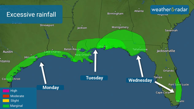
Excessive Rain

Rain showers continue for the northern Gulf Coast Tuesday, with precipitation spreading into the Florida Peninsula. It will be soggy in cities like Tampa and Orlando, Fla., for much of Tuesday and into Wednesday. Rain lingers across Florida and into South Georgia mid-week before the low moves out Thursday.

Flash flooding is possible, but the threat is low and mainly confined to more urban communities. Marginal risks of excessive rainfall are in place along parts of the Gulf Coast for the next few days. A marginal risk of excessive rainfall is a level one out of four. Stay alert and do not drive over a flooded road.

So how much rain will fall? From Texas to Florida, 2 to 4 inches of rain, with locally higher amounts up to 6 inches is expected. It's not enough rain to get rid of the drought in the driest locations, but any amount helps.

More on the topic
Meteorological vs astronomical autumn. Season start date. . . Tuesday, September 1, 2026
Tuesday, September 1, 2026

Season start date

Meteorological vs astronomical autumn
Hurricane parade in the Pacific. Karina is very strong. . Weather Videos. Tuesday, September 1, 2026
WindRadar for Friday, showing the three hurricanes – Lowell, Karina and Maria – over the Pacific.
Weather VideosTuesday, September 1, 2026

Karina is very strong

Hurricane parade in the Pacific
All about nocturnal severe weather. Risks & preparedness. . . Saturday, August 22, 2026
Saturday, August 22, 2026

Risks & preparedness

All about nocturnal severe weather
All weather news
This might also interest you
More signs of autumn. Cooler days ahead. . . Friday, September 18, 2026
Friday, September 18, 2026

Cooler days ahead

More signs of autumn
12+ foot waves, gusty winds. Season's first Nor'easter. . . Wednesday, September 23, 2026
Wednesday, September 23, 2026

Season's first Nor'easter

12+ foot waves, gusty winds
30-degree drop on heels of equinox. Mid-Atlantic & Southeast. . . Monday, September 21, 2026
Monday, September 21, 2026

Mid-Atlantic & Southeast

30-degree drop on heels of equinox
All articles
Weather & Radar

Weather & Radar is also available on

Google Play StoreApp Store

Company

Contact us Privacy policy Legal info Accessibility statement

Services

Uploader

Socials

instagramfacebookthreadslinkList