Home
Weather New York
WeatherRadar
RainRadar
TemperatureRadar
WindRadar
LightningRadar
Weather News
Editor's Pick
Discover the app
Weather widget
Contact us
Apps
Career
    Home / Weather News /

    Not just the winds - Tropical storm & hurricane hazards

09:02 PM
May 22, 2025

Not just the winds
Tropical storm & hurricane hazards

Privacy policy

It's not just the winds or sideways rain! Let's visit some of the most hazardous impacts of hurricanes and tropical storms.

Tornadoes

Hurricanes and tropical storms produce rain bands that spiral outward from the center. Sometimes, turbulence and rotating air in the rainbands can favor tornado-producing storms. While tornadoes embedded within hurricanes are usually weak and short-lived, they are challenging to predict and cause extensive damage.

Tornadoes are most frequent in the leading right quadrant of the storm, where conditions are often most favorable for rotating air.

Erosion

hurricane

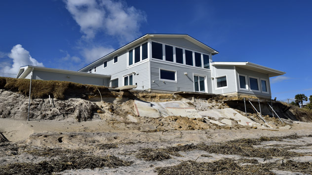
When dealing with a landfalling hurricane, beaches are our natural buffer between the ocean and inland communities, ecosystems, and natural resources. However, these important environments can suffer extreme and catastrophic changes in response to winds, waves and storm surge during a hurricane.

Seawater will inevitably eat away at loose sand, soils or rocks, putting at-risk infrastructure adjacent to the coast. As a result, beaches are stripped of their sand, asphalt along road cracks and homes could lose their foundations.

A paper published in the Journal of Geophysical Research Letters studied the erosion impacts Hurricane Maria had on 75 beaches across Puerto Rico in 2017. The results found at Maria caused erosion of 9 to 15 meters along its path, up to 120 feet at particular beaches. That's roughly the length of an Olympic-sized swimming pool!

Storm surge

When a hurricane or tropical storm makes landfall, seawater can push several miles inland, worsening erosion and flooding communities adjacent to the coast, sometimes several dozen feet deep. Storm surge is the abnormal rise in water pushed in above the forecast astronomical tide.

If the cyclone is exceptionally expansive or powerful, storm surge can often go far beyond the coast. For example, Hurricane Ike carried a storm surge more than 28 miles above land from the coast of Texas and Louisiana. As mentioned before, no storm can be treated alike—how far or how high storm surge can get will depend on the terrain, coastline and storm trajectory.

Becca Parker
More on the topic
How does fog form?. Multiple ways. . . Saturday, July 11, 2026
Saturday, July 11, 2026

Multiple ways

How does fog form?
Super Typhoon Bavi threatens Taiwan. 155 mph winds. . Weather Videos. Wednesday, July 8, 2026
The image shows an intense tropical cyclone over the western Pacific, east of Taiwan and the Philippines. The centre of the system is depicted as a light purple and white vortex with a clearly visible eye, surrounded by a ring of red and orange areas indicating the strongest wind speeds. A white arrow marks the typhoon’s predicted track towards the north-west, in the direction of Taiwan. To the west of the storm lie the Philippines, with the cities of Manila and Cebu; to the north of these lies Taiwan, with Taipei. Further west, the Chinese coast, including Hong Kong, and parts of Vietnam can be seen. The coloured wind map shows predominantly green areas outside the storm’s core, indicating significantly weaker winds. White streamlines illustrate the typhoon’s anti-clockwise circulation in the Northern Hemisphere. The highest wind speeds are concentrated around the eye of the cyclone.
Weather VideosWednesday, July 8, 2026

155 mph winds

Super Typhoon Bavi threatens Taiwan
Rip currents & safety tips. As more head to the coast. . . Sunday, July 5, 2026
rip current
Sunday, July 5, 2026

As more head to the coast

Rip currents & safety tips
All weather news
This might also interest you
Poor air quality to span 1.2K+ miles. Canadian wildfires. . . Wednesday, July 15, 2026
Wednesday, July 15, 2026

Canadian wildfires

Poor air quality to span 1.2K+ miles
Area to watch this weekend. Tropical trouble?. . . Wednesday, July 15, 2026
An area of low pressure is expected to develop this weekend off Florida's Big Bend. The question is: will this mean tropical trouble for the Southeast?
Wednesday, July 15, 2026

Tropical trouble?

Area to watch this weekend
Northern New England storms. Rare severe threat. . . Tuesday, July 14, 2026
Tuesday, July 14, 2026

Rare severe threat

Northern New England storms
All articles
Weather & Radar

Weather & Radar is also available on

Google Play StoreApp Store

Company

Contact us Privacy policy Legal info Accessibility statement

Services

Uploader

Socials

instagramfacebookthreadslinkList