Home
Weather New York
WeatherRadar
RainRadar
TemperatureRadar
WindRadar
LightningRadar
Weather News
Editor's Pick
Discover the app
Weather widget
Contact us
Apps
Career
    Home / Editor's Pick /

    On this day: The 1974 Super Outbreak

12:00 AM
April 4, 2024

It's been 50 years
On this day: The 1974 Super Outbreak

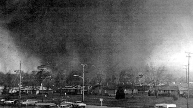
Xenia, Ohio, tornado from April 3, 2024
Xenia, Ohio, tornado from April 3, 2024 - © NWS

It’s been 50 years since the 1974 Super Outbreak, now the second largest 24-hour outbreak since the 2011 Super Outbreak.

Thirteen states were impacted by more than 145 tornadoes within a 24-hour period east of the Mississippi between April 3rd and 4th, 1974.

Thirty of the tornadoes that slammed the 13 states ended up being F4 and F5 strengths. Winds were between 207 to 318 mph! The whole event is remembered by many, but some of the more unforgettable tornadoes touched down in Xenia, Ohio (F5 strength, 36 fatalities, $100 million in damages), Depauw-Daisy Hill, Ind., (first F5 strength during the event, 86 injuries, and 6 fatalities), and Tanner, Ala., (struck by 2 F5 tornadoes that lasted 90 minutes apiece).

Did you know?

The Enhanced Fujita (EF) scale came into effect in 2007.

Alabama had the most fatalities in the entire event with 77. Kentucky was close behind with 71 fatalities.

The weather setup

A large low-pressure system moving across the central Plains along with an associated cold front along its southern flank initiated the severe weather outbreak. On Wednesday, April 3rd, above average temperatures soared into the upper 60s and 70s across the Midwest as warm, water-laden air was swept northward.

The video below shows the low-pressure system from satellite view as storms streaked across the Midwest and South.

Recommended external content from YouTube

We need your consent to show content from YouTube. You can withdraw your consent at any time.

I agree that content from YouTube will be displayed to me.
Privacy policy

The cold front clashed with the warm air mass, producing the dangerous storms. Additionally, a squall line moving into the Midwest early that morning helped initiate later afternoon storms with its leftover energy too.

This storm outbreak was an eye-opener and led to many innovations when it came to weather information, forecasting, and preparedness. In fact, it led to the online promotion of the #SafePlaceSelfie by the National Weather Service to help everyone know the best place to be during a severe weather outbreak, no matter where they are.

You can be prepared for the worst by staying ahead of the forecast with the Weather & Radar app. Download it for free today and stay weather-aware with the helpful WeatherRadar and LightningRadar throughout severe weather season.

Becca Parker
More on the topic
Super Typhoon Bavi threatens Taiwan. 155 mph winds. . Weather Videos. Wednesday, July 8, 2026
The image shows an intense tropical cyclone over the western Pacific, east of Taiwan and the Philippines. The centre of the system is depicted as a light purple and white vortex with a clearly visible eye, surrounded by a ring of red and orange areas indicating the strongest wind speeds. A white arrow marks the typhoon’s predicted track towards the north-west, in the direction of Taiwan. To the west of the storm lie the Philippines, with the cities of Manila and Cebu; to the north of these lies Taiwan, with Taipei. Further west, the Chinese coast, including Hong Kong, and parts of Vietnam can be seen. The coloured wind map shows predominantly green areas outside the storm’s core, indicating significantly weaker winds. White streamlines illustrate the typhoon’s anti-clockwise circulation in the Northern Hemisphere. The highest wind speeds are concentrated around the eye of the cyclone.
Weather VideosWednesday, July 8, 2026

155 mph winds

Super Typhoon Bavi threatens Taiwan
Record-breaking heatwave in Europe. Hotter than most of U.S.. . . Thursday, June 25, 2026
Thursday, June 25, 2026

Hotter than most of U.S.

Record-breaking heatwave in Europe
The best views of Wednesday's eclipse. Europe's sky show. . . Thursday, August 13, 2026
Solar eclipse: The sun obscured between wind turbines in Sardinia
Thursday, August 13, 2026

Europe's sky show

The best views of Wednesday's eclipse
All weather news
This might also interest you
Gravity wave spotted on WeatherRadar. Moving into TN. . . Monday, August 17, 2026
Monday, August 17, 2026

Moving into TN

Gravity wave spotted on WeatherRadar
20 days of at least 100°F. Southern Plains. . . Thursday, August 20, 2026
Thursday, August 20, 2026

Southern Plains

20 days of at least 100°F
Tornado producer brings fall refresh. Northeast low. . . Friday, August 21, 2026
Friday, August 21, 2026

Northeast low

Tornado producer brings fall refresh
All articles
Weather & Radar

Weather & Radar is also available on

Google Play StoreApp Store

Company

Contact us Privacy policy Legal info Accessibility statement

Services

Uploader

Socials

instagramfacebookthreadslinkList