Home
Weather New York
WeatherRadar
RainRadar
TemperatureRadar
WindRadar
LightningRadar
Weather News
Editor's Pick
Discover the app
Weather widget
Contact us
Apps
Career
    Home / Editor's Pick /

    Persistent flood risk -Central Plains saturated, more rains coming

03:14 PM
June 3, 2024

Persistent flood risk
Central Plains saturated & more rain

While the heat continues to torch Southern Texas, the chance for storms will continue across the North. The flood risk continues this week. Let’s dive into the forecast.

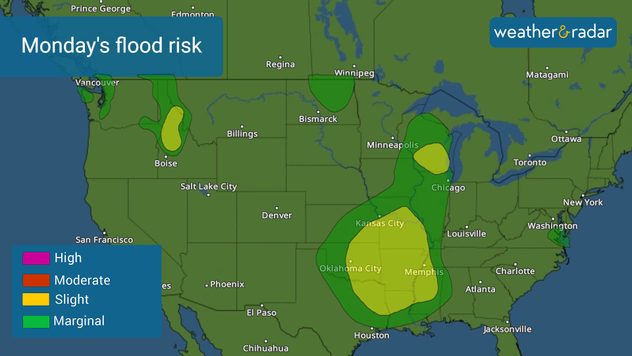
Another week starts and the weather setup continues to be active across the Central Plains. Specifically, the rain will continue across parts of north Texas, Oklahoma, Arkansas, and southern Missouri. It’s not just about the coming rains this week, but also the previous weeks’ systems that have already brought endless showers, saturating the grounds.

Monday's flood risk
Monday's flood risk

The constant passing of low pressures and their frontal boundaries crashing with the heat and the humid air from the Gulf of Mexico will keep the storms and showers present through much of the first week of June. Remember that any additional rain falling over already saturated ground will increase the chance of flooding.

Rain totals through Thursday morning could reach between 2 and 4 inches across eastern Oklahoma, and northern Arkansas, while North Texas will reach up to 3 inches, and some isolated spots could receive 4.5 to 5 inches. Some river levels across eastern Texas are at moderate or close to major levels. Please stay as far away as possible.

You can track the timing and strength of the storms in our weather app and be prepared to face the flooding threat. We will continue to bring you frequent updates throughout the week.

Irene Sans
More on the topic
Hurricane parade in the Pacific. Karina is very strong. . Weather Videos. Tuesday, September 1, 2026
WindRadar for Friday, showing the three hurricanes – Lowell, Karina and Maria – over the Pacific.
Weather VideosTuesday, September 1, 2026

Karina is very strong

Hurricane parade in the Pacific
All about nocturnal severe weather. Risks & preparedness. . . Saturday, September 5, 2026
Saturday, September 5, 2026

Risks & preparedness

All about nocturnal severe weather
Record ocean heat halting hurricanes. Strong El Niño influence. . . Sunday, September 13, 2026
A weather map shows a calm Atlantic Ocean with no hurricanes, alongside a picture of the sea.
Sunday, September 13, 2026

Strong El Niño influence

Record ocean heat halting hurricanes
All weather news
This might also interest you
Autumn foliage: weather's impact. Leaf-peeping season!. . . Sunday, October 4, 2026
Cool nights can help intensify autumn foliage color!
Sunday, October 4, 2026

Leaf-peeping season!

Autumn foliage: weather's impact
October astro outlook. Look up!. . . Saturday, October 3, 2026
Star gazing - Astro outlook
Saturday, October 3, 2026

Look up!

October astro outlook
First hurricane of the Atlantic season. Isaias forms. . . Thursday, October 8, 2026
After a quiet start, the Atlantic's first hurricane has finally formed. Isaias is the latest first hurricane since the satellite era began in1966. With the Gulf Coast in sight, what impacts are expected?
Thursday, October 8, 2026

Isaias forms

First hurricane of the Atlantic season
All articles
Weather & Radar

Weather & Radar is also available on

Google Play StoreApp Store

Company

Contact us Privacy policy Legal info Accessibility statement

Services

Uploader

Socials

instagramfacebookthreadslinkList