Home
Weather New York
WeatherRadar
RainRadar
TemperatureRadar
WindRadar
LightningRadar
Weather News
Editor's Pick
Discover the app
Weather widget
Contact us
Apps
Career
    Home / Editor's Pick /

    Power outages and flight cancellations: Dust storm hits major city in the USA

11:00 AM
August 31, 2025

Fascinating phenomenon
Dust storm hit Phoenix last week

Privacy policy

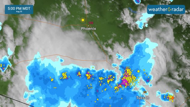
In the otherwise mostly dry south-west of the USA, powerful thunderstorms are currently developing frequently. They can trigger huge dust storms, known as haboobs.

In the deserts of Arizona, a huge wall of dust hit the city of Phoenix in recent days.

WeatherRadar: Severe thunderstorms are discharging south of Phoenix, triggering a large dust storm.

As a result, more than 15,000 people were left without electricity. Visibility dropped to just a few feet, forcing motorists to stop. Flight operations also had to be temporarily suspended.

Burning Man festival interrupted due to storm

The Burning Man art festival in the desert in the US state of Nevada had to be temporarily interrupted due to a dust storm. Gusts of more than 43 mph destroyed art installations and tore down the tents of numerous visitors.

Mary Mays
More on the topic
How does fog form?. Multiple ways. . . Saturday, July 11, 2026
Saturday, July 11, 2026

Multiple ways

How does fog form?
Super Typhoon Bavi threatens Taiwan. 155 mph winds. . Weather Videos. Wednesday, July 8, 2026
The image shows an intense tropical cyclone over the western Pacific, east of Taiwan and the Philippines. The centre of the system is depicted as a light purple and white vortex with a clearly visible eye, surrounded by a ring of red and orange areas indicating the strongest wind speeds. A white arrow marks the typhoon’s predicted track towards the north-west, in the direction of Taiwan. To the west of the storm lie the Philippines, with the cities of Manila and Cebu; to the north of these lies Taiwan, with Taipei. Further west, the Chinese coast, including Hong Kong, and parts of Vietnam can be seen. The coloured wind map shows predominantly green areas outside the storm’s core, indicating significantly weaker winds. White streamlines illustrate the typhoon’s anti-clockwise circulation in the Northern Hemisphere. The highest wind speeds are concentrated around the eye of the cyclone.
Weather VideosWednesday, July 8, 2026

155 mph winds

Super Typhoon Bavi threatens Taiwan
Waterspouts possible, what are they?. They can be dangerous. . . Sunday, August 9, 2026
Waterspouts weatherradar.
Sunday, August 9, 2026

They can be dangerous

Waterspouts possible, what are they?
All weather news
This might also interest you
Heat not felt in 80+ years. Pacific Northwest. . . Tuesday, August 4, 2026
Records as old as 81 and even 124 years could fall this first week of August in the Pacific Northwest as temperatures rise to the 90s & triple digits due to a new heatwave.
Tuesday, August 4, 2026

Pacific Northwest

Heat not felt in 80+ years
Be ready for tropical activity. Tips & tools. . . Saturday, August 8, 2026
Track hurricanes with the WeatherRadar
Saturday, August 8, 2026

Tips & tools

Be ready for tropical activity
Watch storm clusters interact. A busy WeatherRadar. . . Tuesday, August 11, 2026
Tuesday, August 11, 2026

A busy WeatherRadar

Watch storm clusters interact
All articles
Weather & Radar

Weather & Radar is also available on

Google Play StoreApp Store

Company

Contact us Privacy policy Legal info Accessibility statement

Services

Uploader

Socials

instagramfacebookthreadslinkList