Home
Weather New York
WeatherRadar
RainRadar
TemperatureRadar
WindRadar
LightningRadar
Weather News
Editor's Pick
Discover the app
Weather widget
Contact us
Apps
Career
    Home / Weather News /

    Tropical Storm Dolly - Atlantic springs into activity

06:27 PM
August 27, 2026

Tropical Storm Dolly
Atlantic springs into activity

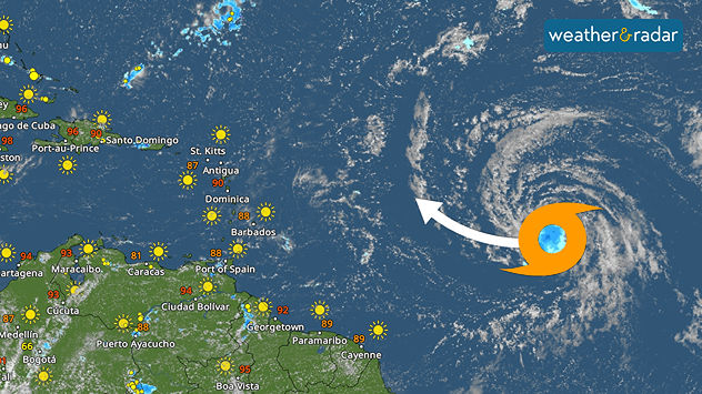
Tropical Storm Dolly is heading west-northwest toward the Caribbean.

Tropical Storm Dolly has formed in the Atlantic, but this is not just any tropical cyclone. Although the forecast looks favorable for the Caribbean, one key question remains: Will the tropical storm have enough strength to reach the islands?

Dolly was officially named on Thursday morning after it developed a well-defined center of circulation and maximum sustained winds of 40 mph. It is expected to continue moving rapidly toward the west-northwest over the next three days, steered by a strong Bermuda high-pressure system.

Privacy policy

Dolly will have only a brief opportunity to strengthen before encountering increasing southwesterly wind shear and dry air beginning Friday. The Leeward Islands could experience periods of heavy rain between Saturday and Sunday, while the Virgin Islands, Puerto Rico, and Hispaniola could see heavy rainfall between Sunday and Monday. Because of the continuous drought, there is a risk of flash flooding, especially in mountainous areas.

The Atlantic hurricane season continues to be unusually quiet. In addition, no hurricanes have developed in the Atlantic basin so far, meaning all indications are that August will end without the formation of a single hurricane.

Becca Parker
More on the topic
Super Typhoon Bavi threatens Taiwan. 155 mph winds. . Weather Videos. Wednesday, July 8, 2026
The image shows an intense tropical cyclone over the western Pacific, east of Taiwan and the Philippines. The centre of the system is depicted as a light purple and white vortex with a clearly visible eye, surrounded by a ring of red and orange areas indicating the strongest wind speeds. A white arrow marks the typhoon’s predicted track towards the north-west, in the direction of Taiwan. To the west of the storm lie the Philippines, with the cities of Manila and Cebu; to the north of these lies Taiwan, with Taipei. Further west, the Chinese coast, including Hong Kong, and parts of Vietnam can be seen. The coloured wind map shows predominantly green areas outside the storm’s core, indicating significantly weaker winds. White streamlines illustrate the typhoon’s anti-clockwise circulation in the Northern Hemisphere. The highest wind speeds are concentrated around the eye of the cyclone.
Weather VideosWednesday, July 8, 2026

155 mph winds

Super Typhoon Bavi threatens Taiwan
How does fog form?. Multiple ways. . . Saturday, July 11, 2026
Saturday, July 11, 2026

Multiple ways

How does fog form?
Europe: Warmest June on record. Warm waters too. . . Friday, July 10, 2026
The record-breaking heatwave in June has made climate history in Western Europe.
Friday, July 10, 2026

Warm waters too

Europe: Warmest June on record
All weather news
This might also interest you
Gravity wave clouds explained. The ideal conditions. . . Saturday, August 22, 2026
Saturday, August 22, 2026

The ideal conditions

Gravity wave clouds explained
20 days of at least 100°F. Southern Plains. . . Thursday, August 20, 2026
Thursday, August 20, 2026

Southern Plains

20 days of at least 100°F
Wildfire explodes to 15k+ acres. Air quality concerns. . . Monday, August 24, 2026
Monday, August 24, 2026

Air quality concerns

Wildfire explodes to 15k+ acres
All articles
Weather & Radar

Weather & Radar is also available on

Google Play StoreApp Store

Company

Contact us Privacy policy Legal info Accessibility statement

Services

Uploader

Socials

instagramfacebookthreadslinkList