Home
Weather New York
WeatherRadar
RainRadar
TemperatureRadar
WindRadar
LightningRadar
Weather News
Editor's Pick
Discover the app
Weather widget
Contact us
Apps
Career
    Home / Weather News /

    Quiet spell ends? - Tropical wave on the move, Caribbean rains

05:18 PM
July 27, 2024

Quiet spell ends?
Tropical wave on the move, Caribbean rains

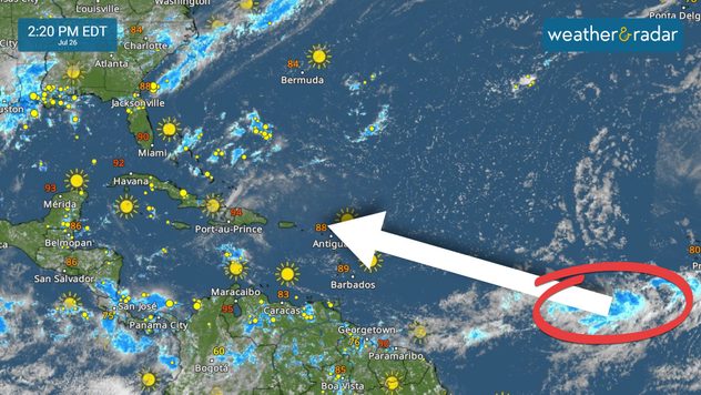
It's been a couple of weeks of benign weather in the tropics, but this could change next week as a tropical wave has a low chance of developing.

There is a plume of Saharan dust traveling over the Caribbean, it will move over the Yucatán Peninsula late this weekend and reach South Texas early next week. The tropical wave follows this plume of dust and is expected to enter more favorable conditions to develop late next week.

Deep tropical moisture will take over the eastern Caribbean by the middle of the week, but the wave at this point will likely still be very disorganized, and losing speed. But by Friday higher tropical moisture, enhancing heavy thunderstorms will move over Florida making way for what could be a very wet weekend, especially for the southern half of the State.

It is likely that this system will emerge over the warm Gulf of Mexico and could intensify further. We have plenty of time to monitor this system and prepare if it threatens your area. Check back for our updates.

Irene Sans
More on the topic
Record-breaking heatwave in Europe. Hotter than most of U.S.. . . Thursday, June 25, 2026
Thursday, June 25, 2026

Hotter than most of U.S.

Record-breaking heatwave in Europe
Super Typhoon Bavi threatens Taiwan. 155 mph winds. . Weather Videos. Wednesday, July 8, 2026
The image shows an intense tropical cyclone over the western Pacific, east of Taiwan and the Philippines. The centre of the system is depicted as a light purple and white vortex with a clearly visible eye, surrounded by a ring of red and orange areas indicating the strongest wind speeds. A white arrow marks the typhoon’s predicted track towards the north-west, in the direction of Taiwan. To the west of the storm lie the Philippines, with the cities of Manila and Cebu; to the north of these lies Taiwan, with Taipei. Further west, the Chinese coast, including Hong Kong, and parts of Vietnam can be seen. The coloured wind map shows predominantly green areas outside the storm’s core, indicating significantly weaker winds. White streamlines illustrate the typhoon’s anti-clockwise circulation in the Northern Hemisphere. The highest wind speeds are concentrated around the eye of the cyclone.
Weather VideosWednesday, July 8, 2026

155 mph winds

Super Typhoon Bavi threatens Taiwan
High pressure & extreme heat. Why & how does it work?. . . Sunday, July 12, 2026
Sunday, July 12, 2026

Why & how does it work?

High pressure & extreme heat
All weather news
This might also interest you
Be prepared for wildfires. By using the app. . . Saturday, July 18, 2026
Wildfires can spark anywhere, anytime. The Weather & Radar app can help you determine your area's risk.
Saturday, July 18, 2026

By using the app

Be prepared for wildfires
Northern New England storms. Rare severe threat. . . Tuesday, July 14, 2026
Tuesday, July 14, 2026

Rare severe threat

Northern New England storms
Area to watch this weekend. Tropical trouble?. . . Wednesday, July 15, 2026
An area of low pressure is expected to develop this weekend off Florida's Big Bend. The question is: will this mean tropical trouble for the Southeast?
Wednesday, July 15, 2026

Tropical trouble?

Area to watch this weekend
All articles
Weather & Radar

Weather & Radar is also available on

Google Play StoreApp Store

Company

Contact us Privacy policy Legal info Accessibility statement

Services

Uploader

Socials

instagramfacebookthreadslinkList