Home
Weather New York
WeatherRadar
RainRadar
TemperatureRadar
WindRadar
LightningRadar
Weather News
Editor's Pick
Discover the app
Weather widget
Contact us
Apps
Career
    Home / Weather News /

    Risk of severe storms increases on Thursday

07:30 PM
March 25, 2026

South of the Great Lakes
Severe storm risk increases Thursday

A spring storm system will bring a risk of thunderstorms Thursday night and early Friday morning across the Midwest. A few storms could be severe.

A cold front pushing across the Midwest from the Plains toward the northern Ohio Valley will bring several bursts of storms starting Thursday afternoon. These bursts will occur in several waves lasting until early Friday morning, with storms potentially affecting the same region and increasing the risk of flash flooding, particularly from western Pennsylvania to central Illinois.

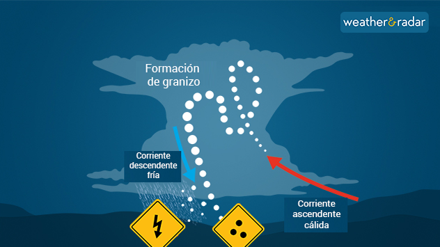
Hail formation
Hail formation

The WeatherRadar shows some storms early Thursday morning over central-eastern Illinois, moving through Ohio. However, the risk of storms with wider coverage and greater intensity will begin affecting Chicago on Thursday starting late in the evening rush hour. As they move east-southeast, they will spread to Detroit, Pittsburgh, Columbus, and Indianapolis, possibly reaching as far south as St. Louis overnight. The greatest risk will be for large hail, with a diameter of at least 2 inches, and destructive winds of at least 58 mph.

Make sure you have at least three ways to receive weather alerts and follow safety guidelines. On Thursday, it would be a good idea to park your vehicle indoors, and when storms are passing through, stay away from windows and doors.

Everything You Need to Know About Severe Nighttime Weatherread more
Irene Sans
More on the topic
Meteorological summer is here!. Bye, spring!. . . Monday, June 1, 2026
Monday, June 1, 2026

Bye, spring!

Meteorological summer is here!
Super Typhoon Bavi threatens Taiwan. 155 mph winds. . Weather Videos. Wednesday, July 8, 2026
The image shows an intense tropical cyclone over the western Pacific, east of Taiwan and the Philippines. The centre of the system is depicted as a light purple and white vortex with a clearly visible eye, surrounded by a ring of red and orange areas indicating the strongest wind speeds. A white arrow marks the typhoon’s predicted track towards the north-west, in the direction of Taiwan. To the west of the storm lie the Philippines, with the cities of Manila and Cebu; to the north of these lies Taiwan, with Taipei. Further west, the Chinese coast, including Hong Kong, and parts of Vietnam can be seen. The coloured wind map shows predominantly green areas outside the storm’s core, indicating significantly weaker winds. White streamlines illustrate the typhoon’s anti-clockwise circulation in the Northern Hemisphere. The highest wind speeds are concentrated around the eye of the cyclone.
Weather VideosWednesday, July 8, 2026

155 mph winds

Super Typhoon Bavi threatens Taiwan
Europe: Warmest June on record. Warm waters too. . . Friday, July 10, 2026
The record-breaking heatwave in June has made climate history in Western Europe.
Friday, July 10, 2026

Warm waters too

Europe: Warmest June on record
All weather news
This might also interest you
Thunderstorms: Anywhere. Anytime.. How do they form?. . . Sunday, August 2, 2026
Sunday, August 2, 2026

How do they form?

Thunderstorms: Anywhere. Anytime.
Big 50-degree jump. Northwest heat extremes. . . Thursday, August 6, 2026
Big temperature jumps
Thursday, August 6, 2026

Northwest heat extremes

Big 50-degree jump
The meeting of the wet masses. A Florida story. . . Wednesday, August 5, 2026
Two air masses conerge to produce storms & heavy downpours across the Florida Peninsula today.
Wednesday, August 5, 2026

A Florida story

The meeting of the wet masses
All articles
Weather & Radar

Weather & Radar is also available on

Google Play StoreApp Store

Company

Contact us Privacy policy Legal info Accessibility statement

Services

Uploader

Socials

instagramfacebookthreadslinkList