Home
Weather New York
WeatherRadar
RainRadar
TemperatureRadar
WindRadar
LightningRadar
Weather News
Editor's Pick
Discover the app
Weather widget
Contact us
Apps
Career
    Home / Weather News /

    Smokehouse Creek Fire grows into largest in history for Texas

06:43 PM
February 28, 2024

Smokehouse Creek Fire
Largest wildfire in state history

Firefighters are battling several wildfires in the Texas Panhandle, the largest being the Smokehouse Creek Fire. While weather conditions will be favorable for containment for a couple of days, dangerous fire weather is expected to return by Friday.

Strong winds, dry fuel, and unseasonable warmth helped fuel a cluster of wildfires in the Texas Panhandle earlier this week. As of Wednesday morning, the largest of the wildfires, the Smokehouse Creek Fire, has expanded to cover 1,075,000 acres (of which 1,050,000 acres have burned in Texas) and is only 3% contained. According to the Texas A&M Forest Service, the Smokehouse Creek Fire is now the largest wildfire on record for the state of Texas.

According to the TemperatureRadar, temperatures were in the 70s on Tuesday as the wildfires exploded across the Texas Panhandle and into Oklahoma. The WindRadar showed gusts as high as 65 mph, making it incredibly difficult to fight the spreading fires. On Tuesday, evacuations were ordered in several towns in a swath northeast of Amarillo, Texas, and officials near Durham, Okla., also encouraged people to flee.

On Tuesday, Texas Governor Greg Abbot issued a disaster declaration for 60 Texas counties, which frees up additional state resources to help with the firefight.

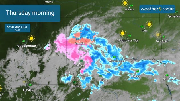
Thursday morning

Thursday will bring light rain and snow to the Panhandle; however, winds will gust up to 30 mph. Dangerous fire weather returns Friday as temperatures surge into the upper 70s, drier air returns, and winds increase to 20 to 30 mph, with higher gusts possible. Weather & Radar's expert meteorologists will keep you up-to-date on the latest.

More on the topic

10 facts about fog. Low clouds. . . Sunday, September 27, 2026
Fog impacting the Appalachian Mountains.
Sunday, September 27, 2026

Low clouds

10 facts about fog
Hurricane Polo remains dangerous. Active Pacific. . . Thursday, September 24, 2026
Thursday, September 24, 2026

Active Pacific

Hurricane Polo remains dangerous
The average first frosts in the U.S.. Meteorological autumn. . . Sunday, October 18, 2026
First frosts can begin in September as autumn temps move in.
Sunday, October 18, 2026

Meteorological autumn

The average first frosts in the U.S.
All weather news

This might also interest you

How atmospheric temps shape winter precipitation. Snow, sleet or ice. . . Sunday, October 25, 2026
Wintry weather impacts D.C. on the WeatherRadar.
Sunday, October 25, 2026

Snow, sleet or ice

How atmospheric temps shape winter precipitation
Severe risk in southern Rockies. Large hail, tornadoes. . . Friday, October 23, 2026
Friday, October 23, 2026

Large hail, tornadoes

Severe risk in southern Rockies
Look up! Those are "Streets Clouds". How do they form?. . . Sunday, October 25, 2026
Sunday, October 25, 2026

How do they form?

Look up! Those are "Streets Clouds"
All articles
Weather & Radar

Weather & Radar is also available on

Google Play StoreApp Store

Company

Contact us Privacy policy Legal info Accessibility statement

Services

Uploader

Socials

instagramfacebookthreadslinkList