Home
Weather New York
WeatherRadar
RainRadar
TemperatureRadar
WindRadar
LightningRadar
Weather News
Editor's Pick
Discover the app
Weather widget
Contact us
Apps
Career
    Home / Weather News /

    Snow for the South

12:07 PM
January 18, 2026

Unusual wintry weather
Snow for the South

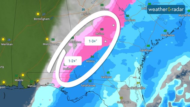
A rare snowstorm is impacting parts of the Southeast this morning, with more than 3 inches of snow possible in parts of central Georgia.

The WeatherRadar shows a cold front moving through the Southeast this morning, turning rain to snow in its wake. Snow showers or a rain-snow mix will spread from the Florida Panhandle into central Georgia before shifting quickly toward the coast this afternoon.

Snow accumulations of a trace to 1 inch are most likely, with isolated areas in central Georgia south of I-85 likely to see 2–4 inches. The highest totals will stretch from Dothan, Ala., to Macon and Warner Robins, Ga.

The highest snow totals will extend from southeast Alabama into central Georgia.

This system will also bring wintry weather to other regions. Snow showers will move up the East Coast into the Mid-Atlantic and Northeast this afternoon and evening. Totals of 3–6 inches, with isolated higher amounts, are possible from the New York City metro area through coastal New England by Monday morning.

Cold air will also stick around, meaning that slick spots will be an issue on Monday morning across the Southeast, Mid-Atlantic and into the Northeast and New England. Any snow that melts has the potential to re-freeze overnight.

Mary Mays
More on the topic
Super Typhoon Bavi threatens Taiwan. 155 mph winds. . Weather Videos. Wednesday, July 8, 2026
The image shows an intense tropical cyclone over the western Pacific, east of Taiwan and the Philippines. The centre of the system is depicted as a light purple and white vortex with a clearly visible eye, surrounded by a ring of red and orange areas indicating the strongest wind speeds. A white arrow marks the typhoon’s predicted track towards the north-west, in the direction of Taiwan. To the west of the storm lie the Philippines, with the cities of Manila and Cebu; to the north of these lies Taiwan, with Taipei. Further west, the Chinese coast, including Hong Kong, and parts of Vietnam can be seen. The coloured wind map shows predominantly green areas outside the storm’s core, indicating significantly weaker winds. White streamlines illustrate the typhoon’s anti-clockwise circulation in the Northern Hemisphere. The highest wind speeds are concentrated around the eye of the cyclone.
Weather VideosWednesday, July 8, 2026

155 mph winds

Super Typhoon Bavi threatens Taiwan
Super Typhoon Near the Philippines. Gusts up to 155. . . Tuesday, June 23, 2026
Tuesday, June 23, 2026

Gusts up to 155

Super Typhoon Near the Philippines
Meteorological summer is here!. Bye, spring!. . . Monday, June 1, 2026
Monday, June 1, 2026

Bye, spring!

Meteorological summer is here!
All weather news
This might also interest you
Area to watch this weekend. Tropical trouble?. . . Wednesday, July 15, 2026
An area of low pressure is expected to develop this weekend off Florida's Big Bend. The question is: will this mean tropical trouble for the Southeast?
Wednesday, July 15, 2026

Tropical trouble?

Area to watch this weekend
Wildfire smoke travels 1K+ miles. Canada to Mid-Atlantic. . . Tuesday, July 14, 2026
Tuesday, July 14, 2026

Canada to Mid-Atlantic

Wildfire smoke travels 1K+ miles
Poor air quality to span 1.2K+ miles. Canadian wildfires. . . Wednesday, July 15, 2026
Wednesday, July 15, 2026

Canadian wildfires

Poor air quality to span 1.2K+ miles
All articles
Weather & Radar

Weather & Radar is also available on

Google Play StoreApp Store

Company

Contact us Privacy policy Legal info Accessibility statement

Services

Uploader

Socials

instagramfacebookthreadslinkList