Home
Weather New York
WeatherRadar
RainRadar
TemperatureRadar
WindRadar
LightningRadar
Weather News
Editor's Pick
Discover the app
Weather widget
Contact us
Apps
Career
    Home / Editor's Pick /

    Spectacular auroras: 1st extreme geomagnetic storm since 2003

05:00 PM
May 13, 2024

Spectacular auroras
1st extreme geomagnetic storm since 2003

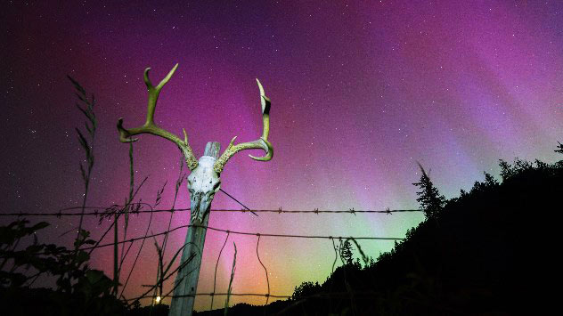
Elkton, Oregon, USA: The aurora borealis,
May 12, 2024, Crater Lake National Park, Oregon, USA:
 San Rafael, California, United States on May 11, 2024. picture alliance / Anadolu | Tayfun Coskun
Picture alliance / ZUMAPRESS.com | Daniel Carde
1/4
May 11, 2024, Elkton, Oregon, USA: The aurora borealis, also known as the northern lights, glow in the sky over a farm pasture near Elkton in southwestern Oregon. (Credit Image: © Robin Loznak/ZUMA Press Wire - © © Robin Loznak/ZUMA Press Wire

Did you see the northern lights this weekend? We witnessed the most extreme geomagnetic storm since 2003.

The morning of Saturday 11th May experienced the 27th strongest solar flare since measurements of the sun began.

This meant that when the coronal mass ejections (CME) collided with the Earth's magnetic field, the charged particles interacted with the gases in our atmosphere, producing the colorful aurora.

There were an unusual array of colors spotted dancing in the sky, up and down in places as far south as Key Largo, Florida, as seen in the selection of photos that were sent into our dedicated uploader. The more common green color indicates a higher concentration of oxygen at lower altitudes, while pinks and purples at higher altitudes were also visible, indicating a greater presence of nitrogen at higher altitudes, but lower oxygen.

Not only did the sun's enhanced activity allow us to see the northern lights, but we very much have the weather to thank for that too. If it weren't for clear skies between 10 pm and 2 am, we wouldn't have stood a chance. The image above from our WeatherRadar shows how much of the United States was cloud-free.

Aurora is best spotted away from light pollution, and the moon was also in our favor as it was in its Waxing Crescent phase, only about 15% illuminated.

Multiple days of risk from TX to FLread more

If you missed out on the sights, do not worry, with activity set to peak into summer 2025, hopefully, there will be more opportunities.

Check out some more pictures seen in the United Kingdom below!

Weather & Radar USA editorial team
More on the topic
Rip currents & safety tips. As more head to the coast. . . Sunday, July 5, 2026
rip current
Sunday, July 5, 2026

As more head to the coast

Rip currents & safety tips
Waterspouts possible, what are they?. They can be dangerous. . . Saturday, July 11, 2026
Waterspouts weatherradar.
Saturday, July 11, 2026

They can be dangerous

Waterspouts possible, what are they?
High pressure & extreme heat. Why & how does it work?. . . Sunday, July 12, 2026
Sunday, July 12, 2026

Why & how does it work?

High pressure & extreme heat
All weather news
This might also interest you
Turning hot this weekend. Brutal temps across West. . . Friday, July 10, 2026
Saturday & Sunday's highs
Friday, July 10, 2026

Brutal temps across West

Turning hot this weekend
Slow-moving storms and heavy rain. What to look for. . . Monday, July 6, 2026
Monday, July 6, 2026

What to look for

Slow-moving storms and heavy rain
Saharan dust to reach Florida. Dry period expected. . . Tuesday, July 7, 2026
Saharan dust seen on the satllite image (right) moving westward toward Florida. Air quality impacts are expected.
Tuesday, July 7, 2026

Dry period expected

Saharan dust to reach Florida
All articles
Weather & Radar

Weather & Radar is also available on

Google Play StoreApp Store

Company

Contact us Privacy policy Legal info Accessibility statement

Services

Uploader

Socials

instagramfacebookthreadslinkList