Home
Weather New York
WeatherRadar
RainRadar
TemperatureRadar
WindRadar
LightningRadar
Weather News
Editor's Pick
Discover the app
Weather widget
Contact us
Apps
Career
    Home / Weather News /

    Storms for the Plains, Mid-South

02:05 PM
June 1, 2026

Damaging wind & hail
Storms for the Plains, Mid-South

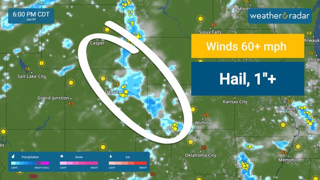
Strong storms target two regions of the U.S. today- the Plains and the Mid-South. Damaging winds and hail are the main threats.

The WeatherRadar shows thunderstorms capable of producing large hail and damaging wind gusts developing this afternoon and evening across portions of the central Plains. Severe weather may impact cities such as Denver, Cheyenne, Wyo., McCook, Neb., and Garden City, Kan.

Strong storms may produce wind gusts higher than 60 mph and hail one inch in diameter or greater.

Farther east and south, scattered to numerous strong-to-severe wind gusts may also occur from the Ozarks into parts of the Southeast. Abundant Gulf moisture will provide ample fuel for storm development before noon today. Storms will fire up through the early afternoon in cities like Nashville and Memphis, Tenn.

A second round of storms may develop across this region this afternoon and evening. Severe storms will also be possible in cities such as Little Rock, Ark., Jackson, Miss., and Birmingham, Ala., in addition to more action across portions of western and middle Tennessee.

Mary Mays
More on the topic
Super Typhoon Bavi threatens Taiwan. 155 mph winds. . Weather Videos. Wednesday, July 8, 2026
The image shows an intense tropical cyclone over the western Pacific, east of Taiwan and the Philippines. The centre of the system is depicted as a light purple and white vortex with a clearly visible eye, surrounded by a ring of red and orange areas indicating the strongest wind speeds. A white arrow marks the typhoon’s predicted track towards the north-west, in the direction of Taiwan. To the west of the storm lie the Philippines, with the cities of Manila and Cebu; to the north of these lies Taiwan, with Taipei. Further west, the Chinese coast, including Hong Kong, and parts of Vietnam can be seen. The coloured wind map shows predominantly green areas outside the storm’s core, indicating significantly weaker winds. White streamlines illustrate the typhoon’s anti-clockwise circulation in the Northern Hemisphere. The highest wind speeds are concentrated around the eye of the cyclone.
Weather VideosWednesday, July 8, 2026

155 mph winds

Super Typhoon Bavi threatens Taiwan
High pressure & extreme heat. Why & how does it work?. . . Sunday, July 12, 2026
Sunday, July 12, 2026

Why & how does it work?

High pressure & extreme heat
Super Typhoon Near the Philippines. Gusts up to 155. . . Tuesday, June 23, 2026
Tuesday, June 23, 2026

Gusts up to 155

Super Typhoon Near the Philippines
All weather news
This might also interest you
Poor air quality to span 1.2K+ miles. Canadian wildfires. . . Wednesday, July 15, 2026
Wednesday, July 15, 2026

Canadian wildfires

Poor air quality to span 1.2K+ miles
SW Texas quadruples its normal July rain. 7 inches and counting. . . Tuesday, July 14, 2026
Tuesday, July 14, 2026

7 inches and counting

SW Texas quadruples its normal July rain
Northern New England storms. Rare severe threat. . . Tuesday, July 14, 2026
Tuesday, July 14, 2026

Rare severe threat

Northern New England storms
All articles
Weather & Radar

Weather & Radar is also available on

Google Play StoreApp Store

Company

Contact us Privacy policy Legal info Accessibility statement

Services

Uploader

Socials

instagramfacebookthreadslinkList