Home
Weather New York
WeatherRadar
RainRadar
TemperatureRadar
WindRadar
LightningRadar
Weather News
Editor's Pick
Discover the app
Weather widget
Contact us
Apps
Career
    Home / Weather News /

    Strong tornadoes possible - Severe storms to last overnight

03:28 PM
March 10, 2026

Strong tornadoes possible
Severe storms to last overnight

A potent storm system will trigger severe storms from the southern Plains to the Midwest on Tuesday, well into the overnight hours.

A low-pressure trough is the main focal point triggering the active weather as dense, cold air lifts the warm, water-laden air mass ahead, causing instability. Closer to the surface, in the southern Plains, storms will fire along the dryline from western Texas into southern Oklahoma.

The WeatherRadar shows these storms firing starting mid-afternoon and slowly shifting east through the overnight. All modes of severe weather are expected, with damaging winds and large hail being the most prevalent.

Along a cold front from the mid-Mississippi Valley into the Midwest, all the way to southern Michigan and Northeast Ohio, storms will begin to fire between 3 and 5 p.m. local time and continue through the nocturnal hours.

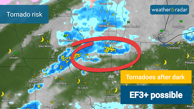
Tuesday's tornado risk
Tornadoes of EF3+ strength possible with this severe system.

Intense tornadoes, damaging winds and large hail are all possible, with cities north of Interstate 72 in Illinois through northern Indiana possibly seeing tornadoes EF3 or higher in strength after dark. This includes southern Chicago suburbs.

Take note during severe storms

Nocturnal severe storms are more dangerous due to lightning being the only source of tornado visibility.

Have at least three ways to receive a weather warning. Have your notification volume turned up while you sleep in case of a tornado event in your area.

Be ready when severe storms strikeread more
Becca Parker
More on the topic
Record-breaking heatwave in Europe. Hotter than most of U.S.. . . Thursday, June 25, 2026
Thursday, June 25, 2026

Hotter than most of U.S.

Record-breaking heatwave in Europe
High pressure & extreme heat. Why & how does it work?. . . Sunday, July 12, 2026
Sunday, July 12, 2026

Why & how does it work?

High pressure & extreme heat
Super Typhoon Bavi threatens Taiwan. 155 mph winds. . Weather Videos. Wednesday, July 8, 2026
The image shows an intense tropical cyclone over the western Pacific, east of Taiwan and the Philippines. The centre of the system is depicted as a light purple and white vortex with a clearly visible eye, surrounded by a ring of red and orange areas indicating the strongest wind speeds. A white arrow marks the typhoon’s predicted track towards the north-west, in the direction of Taiwan. To the west of the storm lie the Philippines, with the cities of Manila and Cebu; to the north of these lies Taiwan, with Taipei. Further west, the Chinese coast, including Hong Kong, and parts of Vietnam can be seen. The coloured wind map shows predominantly green areas outside the storm’s core, indicating significantly weaker winds. White streamlines illustrate the typhoon’s anti-clockwise circulation in the Northern Hemisphere. The highest wind speeds are concentrated around the eye of the cyclone.
Weather VideosWednesday, July 8, 2026

155 mph winds

Super Typhoon Bavi threatens Taiwan
All weather news
This might also interest you
100 miles, 30-degree difference. Southern California. . . Thursday, July 9, 2026
Thursday, July 9, 2026

Southern California

100 miles, 30-degree difference
Lightning season in full bloom. Staying safe this summer. . . Monday, July 6, 2026
Monday, July 6, 2026

Staying safe this summer

Lightning season in full bloom
Slow-moving storms and heavy rain. What to look for. . . Monday, July 6, 2026
Monday, July 6, 2026

What to look for

Slow-moving storms and heavy rain
All articles
Weather & Radar

Weather & Radar is also available on

Google Play StoreApp Store

Company

Contact us Privacy policy Legal info Accessibility statement

Services

Uploader

Socials

instagramfacebookthreadslinkList