Home
Weather New York
WeatherRadar
RainRadar
TemperatureRadar
WindRadar
LightningRadar
Weather News
Editor's Pick
Discover the app
Weather widget
Contact us
Apps
Career
    Home / Editor's Pick /

    SW Iceland braces for possible eruption after 30,000 earthquakes

09:00 PM
November 14, 2023

30,000 earthquakes
SW Iceland braces for possible eruption

Recommended external content from YouTube

We need your consent to show content from YouTube. You can withdraw your consent at any time.
I agree that content from YouTube will be displayed to me.
Privacy policy

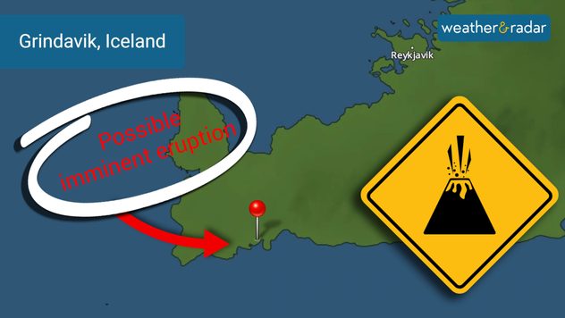
Iceland is bracing for a possible volcanic eruption as thousands of earthquakes have taken place over the last several weeks. Evacuations occurred over the weekend in the midst of a state of emergency.

30,000 earthquakes have rumbled underneath the feet of southwest Iceland over the last three weeks. The town of Grindavik is under high alert and most residents have evacuated with the highly anticipated volcanic eruption off the Reykjanes peninsula.

Grindavik is under a state of emergency due to the anticipated volcanic eruption.
Grindavik is under a state of emergency due to the anticipated volcanic eruption. - © Weather & Radar USA

However, the evacuations came with a “remain calm” attitude due to authorities believing there to be plenty of time to safely leave Grindavik ahead of a possible eruption.

A 9-mile river of magma has been reported by University of Iceland volcanology professor, Thor Thordason, under the peninsula. In 24 hours from Wednesday to Thursday of last week, more than 1,000 earthquakes occurred in the area, prompting the evacuation order.

The Fagradalsfjall volcano has had thousands of earthquakes surrounding it since late October, with the magnitudes ranging between little shakes to up to magnitude 5.1. The peninsula was quiet for 800 years until a 2021 eruption. Subsequent eruptions have occurred each year since then.

The Blue Lagoon, known to many of Iceland’s visitors, has been closed due to the activity until November 30.

Experts say it is hard to determine when and where the river of magma flowing underneath the peninsula will reach the surface – it is currently around 3 miles underground. An aviation alert has been issued as well to keep pilots on their toes about possible ash being aggressively spewed upwards should an eruption occur.

Iceland is home to 130 mostly active volcanoes, so the activity is no stranger to its residents. However, if predictions are correct, the possible eruption could be larger than previous eruptions recorded for the Fagradalsfjall volcano.

Becca Parker
More on the topic
Rip currents & safety tips. As more head to the coast. . . Sunday, July 5, 2026
rip current
Sunday, July 5, 2026

As more head to the coast

Rip currents & safety tips
Super Typhoon Bavi threatens Taiwan. 155 mph winds. . Weather Videos. Wednesday, July 8, 2026
The image shows an intense tropical cyclone over the western Pacific, east of Taiwan and the Philippines. The centre of the system is depicted as a light purple and white vortex with a clearly visible eye, surrounded by a ring of red and orange areas indicating the strongest wind speeds. A white arrow marks the typhoon’s predicted track towards the north-west, in the direction of Taiwan. To the west of the storm lie the Philippines, with the cities of Manila and Cebu; to the north of these lies Taiwan, with Taipei. Further west, the Chinese coast, including Hong Kong, and parts of Vietnam can be seen. The coloured wind map shows predominantly green areas outside the storm’s core, indicating significantly weaker winds. White streamlines illustrate the typhoon’s anti-clockwise circulation in the Northern Hemisphere. The highest wind speeds are concentrated around the eye of the cyclone.
Weather VideosWednesday, July 8, 2026

155 mph winds

Super Typhoon Bavi threatens Taiwan
Record-breaking heatwave in Europe. Hotter than most of U.S.. . . Thursday, June 25, 2026
Thursday, June 25, 2026

Hotter than most of U.S.

Record-breaking heatwave in Europe
All weather news
This might also interest you
Slow-moving storms and heavy rain. What to look for. . . Monday, July 6, 2026
Monday, July 6, 2026

What to look for

Slow-moving storms and heavy rain
Saharan dust to reach Florida. Dry period expected. . . Tuesday, July 7, 2026
Saharan dust seen on the satllite image (right) moving westward toward Florida. Air quality impacts are expected.
Tuesday, July 7, 2026

Dry period expected

Saharan dust to reach Florida
Follow the clouds. High-pressure ridge. . . Monday, July 13, 2026
Monday, July 13, 2026

High-pressure ridge

Follow the clouds
All articles
Weather & Radar

Weather & Radar is also available on

Google Play StoreApp Store

Company

Contact us Privacy policy Legal info Accessibility statement

Services

Uploader

Socials

instagramfacebookthreadslinkList