Home
Weather New York
WeatherRadar
RainRadar
TemperatureRadar
WindRadar
LightningRadar
Weather News
Editor's Pick
Discover the app
Weather widget
Contact us
Apps
Career
    Home / Weather News /

    The Endlerin N.D., tornado classification is now classified as an EF-5.

07:09 PM
October 6, 2025

210+ mph
12 year EF-5 tornado drought over

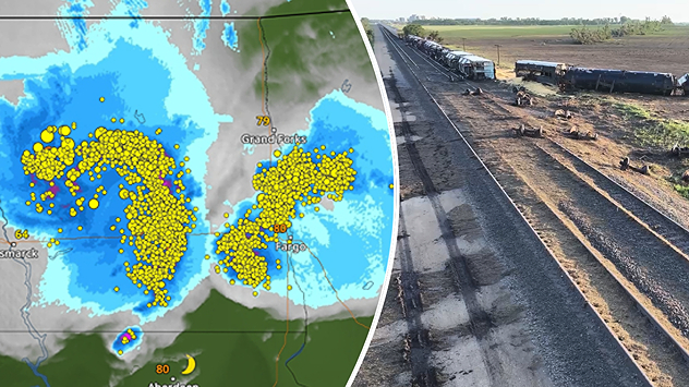
Enderlin, N.D., severe tornado outbreak & train derailment image captured by WxChasing.
Enderlin, N.D., severe tornado outbreak & train derailment image captured by WxChasing. - © Right image: WxChasing

On June 20, 2025, Enderlin, N.D., experienced a powerful tornado, once thought to have been an EF-3 in strength. After further investigation, the National Weather Service (NWS) has increased the tornado classification to EF-5 strength, ending the 12-year-long EF-5 tornado drought.

Last EF-5

The last recorded EF-5 occurred on May 20, 20213 in Moore, Okla., killing 24 people and injuring more than 200 others. 

North Dakota experienced an overnight derecho and deadly tornado outbreak in June 2025. The Enderlin, N.D., tornado was a preliminary EF-3 (136 - 165 mph) during initial surveys, but after working with wind damage experts and further investigation, the NWS declared it an EF-5 strength as of Monday, October 6, 2025.

Privacy policy

Officials have declared the tornado to have had wind speeds greater than 210 mph at the time of a train derailment. "The analysis involved forensic damage wind speed estimates for tipping severalfully-loaded grain hopper cars and lofting of tanker cars, including one empty tanker carthat was tossed about 475.7 ft (145 m)." That's about one and a half Statues of Liberty.

EF-5 tornadoes are rare but extremely dangerous. Keep an eye on the WeatherRadar when severe storms threaten your area and turn on your alerts.

Becca Parker
More on the topic
Longest day of the year is here. Summer solstice. . . Sunday, June 21, 2026
Sunday, June 21, 2026

Summer solstice

Longest day of the year is here
The only Blue Moon of the year rises. May astronomy outlook. . . Saturday, May 2, 2026
Saturday, May 2, 2026

May astronomy outlook

The only Blue Moon of the year rises
El Niño is gaining momentum. Temperature records?. . . Thursday, May 7, 2026
The image shows the central Pacific in a computer model. A striking feature is the ocean coloured red, which indicates very warm seawater.
Thursday, May 7, 2026

Temperature records?

El Niño is gaining momentum
All weather news
This might also interest you
Lightning season in full bloom. Staying safe this summer. . . Monday, July 6, 2026
Monday, July 6, 2026

Staying safe this summer

Lightning season in full bloom
Hotter in Detroit than Miami. Heatwave begins. . . Tuesday, June 30, 2026
Tuesday, June 30, 2026

Heatwave begins

Hotter in Detroit than Miami
Tough sleeping temperatures too. Stifling hot night & day. . . Thursday, July 2, 2026
Friday's temperatures
Thursday, July 2, 2026

Stifling hot night & day

Tough sleeping temperatures too
All articles
Weather & Radar

Weather & Radar is also available on

Google Play StoreApp Store

Company

Contact us Privacy policy Legal info Accessibility statement

Services

Uploader

Socials

instagramfacebookthreadslinkList