Home
Weather New York
WeatherRadar
RainRadar
TemperatureRadar
WindRadar
LightningRadar
Weather News
Editor's Pick
Discover the app
Weather widget
Contact us
Apps
Career
    Home / Weather News /

    Through the weekend - Multi-day severe threat starts Thursday

08:19 PM
April 22, 2026

Through the weekend
Multi-day severe threat starts Thursday

Severe storms are in the forecast through the beginning of the coming week for high-population spots in the central U.S. Those from the Plains and Ozarks through the Midwest will need to pay close attention to the forecast.

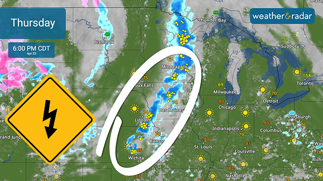
Starting Thursday, a low pressure system carrying a potent cold front will swing east from the Rockies and run into a warm, water-laden air mass. This will trigger severe storms from Wichita Falls, Texas, to northern Minnesota and Wisconsin, especially from eastern Kansas to Minneapolis. Tornadoes, damaging winds and hail are all expected.

Severe storms are expected during the afternoon rush hour from the centreal Plains to the Midwest.
Severe storms are expected during the afternoon rush hour from the central Plains to the Midwest.

By Friday, the front shifts south and east. While thunderstorms are expected throughout the day, severe storms are possible with the afternoon heating. This includes a tornado risk, especially for those from Dallas to southern Missouri.

We have an eye on weekend severe storms for the central and southern Plains. Residents with outdoor plans should keep a close eye on the WeatherRadar and have their alerts switched on.

Have you used our new feature?read more
Becca Parker
More on the topic
Record-breaking heatwave in Europe. Hotter than most of U.S.. . . Thursday, June 25, 2026
Thursday, June 25, 2026

Hotter than most of U.S.

Record-breaking heatwave in Europe
Super Typhoon Bavi threatens Taiwan. 155 mph winds. . Weather Videos. Wednesday, July 8, 2026
The image shows an intense tropical cyclone over the western Pacific, east of Taiwan and the Philippines. The centre of the system is depicted as a light purple and white vortex with a clearly visible eye, surrounded by a ring of red and orange areas indicating the strongest wind speeds. A white arrow marks the typhoon’s predicted track towards the north-west, in the direction of Taiwan. To the west of the storm lie the Philippines, with the cities of Manila and Cebu; to the north of these lies Taiwan, with Taipei. Further west, the Chinese coast, including Hong Kong, and parts of Vietnam can be seen. The coloured wind map shows predominantly green areas outside the storm’s core, indicating significantly weaker winds. White streamlines illustrate the typhoon’s anti-clockwise circulation in the Northern Hemisphere. The highest wind speeds are concentrated around the eye of the cyclone.
Weather VideosWednesday, July 8, 2026

155 mph winds

Super Typhoon Bavi threatens Taiwan
Europe: Warmest June on record. Warm waters too. . . Friday, July 10, 2026
The record-breaking heatwave in June has made climate history in Western Europe.
Friday, July 10, 2026

Warm waters too

Europe: Warmest June on record
All weather news
This might also interest you
Dangerous air quality continues. Canada wildfires smoke. . . Friday, July 17, 2026
Smoky Philadelphia
Friday, July 17, 2026

Canada wildfires smoke

Dangerous air quality continues
Up to four feet of storm surge. Gulf Coast soaker. . . Tuesday, July 21, 2026
Tropical storm alerts are active in the app as Bertha continues to churn in the northern Gulf.
Tuesday, July 21, 2026

Gulf Coast soaker

Up to four feet of storm surge
How does a hurricane form?. Hurricane preparedness. . . Sunday, July 19, 2026
hurricane maria
Sunday, July 19, 2026

Hurricane preparedness

How does a hurricane form?
All articles
Weather & Radar

Weather & Radar is also available on

Google Play StoreApp Store

Company

Contact us Privacy policy Legal info Accessibility statement

Services

Uploader

Socials

instagramfacebookthreadslinkList