Home
Weather New York
WeatherRadar
RainRadar
TemperatureRadar
WindRadar
LightningRadar
Weather News
Editor's Pick
Discover the app
Weather widget
Contact us
Apps
Career
    Home / Weather News /

    Today's daily briefing: West stays busy

10:00 AM
January 2, 2026

Today's daily briefing
West stays busy

After a soggy New Year's Day, California and the West Coast will slowly get a chance to dry out before the next storm comes in this evening. The South will have to contend with its own batch of showers today. This, along with a look at the rest of the U.S.'s weather, is included in today's daily briefing, published every weekday at 5 a.m. ET.

The WeatherRadar shows yesterday's West Coast rainmaker slowly fading away today, bringing valley showers and mountain snow to the Northwest, Intermountain West, Great Basin and the length of the Rockies. The immediate West Coast could see a fresh batch of rain later today and tonight as a new Pacific storm system edges closer.

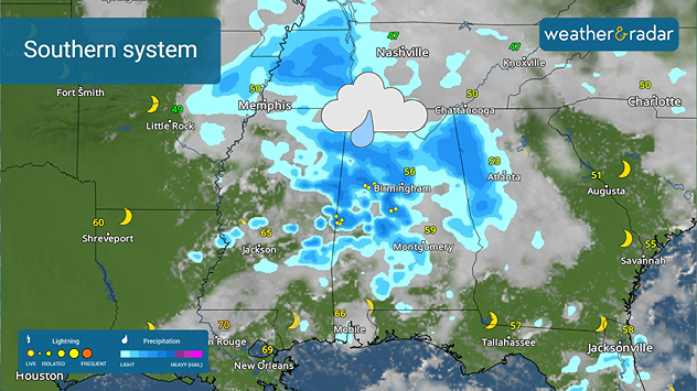
Southern system
Rain spreads across the South.

A new storm system will develop this afternoon across the lower Mississippi Valley and the South. This will produce afternoon showers. A rumble of thunder cannot be ruled out closer to the Gulf Coast.

A bit of snow and a frozen mix will also be possible across the northern and central Plains, Northeast and into northern New England. Otherwise, the rest of the U.S. will be quiet heading into 2026's first weekend.

The TemperatureRadar shows afternoon highs ranging from the teens and 20s in the northern Plains, Great Lakes and the Northeast to much warmer 70s and 80s across Texas, the Gulf Coast and Florida. Most other places will be in the 30s and 40s, with the southern tier from southern California to the Southeast being in the 60s.

Wanting to start off that New Year's resolution on the right foot and get outside for a walk? Want to know how the Weather & Radar app can help? You can see all of our features at a glance using the Discover the App feature.

James West
More on the topic
Super Typhoon Near the Philippines. Gusts up to 155. . . Tuesday, June 23, 2026
Tuesday, June 23, 2026

Gusts up to 155

Super Typhoon Near the Philippines
Meteorological summer is here!. Bye, spring!. . . Monday, June 1, 2026
Monday, June 1, 2026

Bye, spring!

Meteorological summer is here!
El Niño is gaining momentum. Temperature records?. . . Thursday, May 7, 2026
The image shows the central Pacific in a computer model. A striking feature is the ocean coloured red, which indicates very warm seawater.
Thursday, May 7, 2026

Temperature records?

El Niño is gaining momentum
All weather news
This might also interest you
Turning hot this weekend. Brutal temps across West. . . Friday, July 10, 2026
Saturday & Sunday's highs
Friday, July 10, 2026

Brutal temps across West

Turning hot this weekend
Tough sleeping temperatures too. Stifling hot night & day. . . Thursday, July 2, 2026
Friday's temperatures
Thursday, July 2, 2026

Stifling hot night & day

Tough sleeping temperatures too
Saharan dust to reach Florida. Dry period expected. . . Tuesday, July 7, 2026
Saharan dust seen on the satllite image (right) moving westward toward Florida. Air quality impacts are expected.
Tuesday, July 7, 2026

Dry period expected

Saharan dust to reach Florida
All articles
Weather & Radar

Weather & Radar is also available on

Google Play StoreApp Store

Company

Contact us Privacy policy Legal info Accessibility statement

Services

Uploader

Socials

instagramfacebookthreadslinkList