Home
Weather New York
WeatherRadar
RainRadar
TemperatureRadar
WindRadar
LightningRadar
Weather News
Editor's Pick
Discover the app
Weather widget
Contact us
Apps
Career
    Home / Weather News /

    Tracking intense Hurricane Melissa

02:16 PM
October 28, 2025

All eyes on Jamaica
Tracking intense Hurricane Melissa

Hurricane Melissa is an intense Category 5 storm with sustained winds of 185 mph, making it one of the most intense on record. Jamaica is bracing for torrential rain, hurricane-force winds, dangerous landslides and life-threatening storm surge.

Hurricane Melissa has continued to intensify overnight and this morning. NOAA's Hurricane Hunters have observed sustained winds of 185 mph and a central pressure of 892 mb, making Melissa the third strongest storm on record in the Atlantic Basin.

Hurricane Melissa, which has been slowly swirling south of Jamaica over warm Caribbean waters, is now being pulled north-northeast by an approaching cold front and is expected to make landfall on the island late Tuesday morning or early afternoon.

Inland flooding is a significant concern as up to 40 inches of rain could fall in southern Hispaniola and Jamaica through Wednesday. Storm surge of 9 to 13 feet is anticipated on Jamaica's southern coast, with 2 to 4 feet of surge expected on the northern end of the island near Montego Bay.

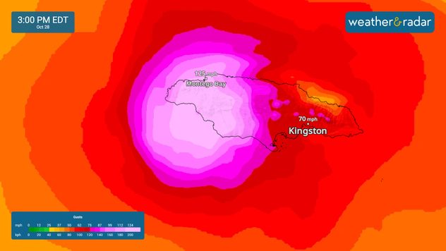
The WindRadar shows hurricane-force winds across western Jamaica.

Melissa will push into eastern Cuba as still a major hurricane tonight or early Wednesday before quickly moving through the southeast Bahamas and Turks and Caicos on Wednesday at hurricane strength.

Mary Mays
More on the topic
What are weather fronts?. Weather explained. . . Sunday, August 23, 2026
Image of a temperature radar showing a clear distinction between a warm and cold air mass separated by a cold front.
Sunday, August 23, 2026

Weather explained

What are weather fronts?
High pressure & extreme heat. Why & how does it work?. . . Sunday, July 12, 2026
Sunday, July 12, 2026

Why & how does it work?

High pressure & extreme heat
The best views of Wednesday's eclipse. Europe's sky show. . . Thursday, August 13, 2026
Solar eclipse: The sun obscured between wind turbines in Sardinia
Thursday, August 13, 2026

Europe's sky show

The best views of Wednesday's eclipse
All weather news
This might also interest you
Days of record nighttime heat. Feeling tropical. . . Monday, August 17, 2026
Monday, August 17, 2026

Feeling tropical

Days of record nighttime heat
Rainfall deficit tops a foot. Southeast Florida. . . Tuesday, August 18, 2026
All heat and no rain for Southeast Florida today.
Tuesday, August 18, 2026

Southeast Florida

Rainfall deficit tops a foot
Gravity wave spotted on WeatherRadar. Moving into TN. . . Monday, August 17, 2026
Monday, August 17, 2026

Moving into TN

Gravity wave spotted on WeatherRadar
All articles
Weather & Radar

Weather & Radar is also available on

Google Play StoreApp Store

Company

Contact us Privacy policy Legal info Accessibility statement

Services

Uploader

Socials

instagramfacebookthreadslinkList