Home
Weather New York
WeatherRadar
RainRadar
TemperatureRadar
WindRadar
LightningRadar
Weather News
Editor's Pick
Discover the app
Weather widget
Contact us
Apps
Career
    Home / Editor's Pick /

    Tropical development? Over a foot of rain possible for parts of Florida

02:04 PM
June 11, 2024

Tropical development?
Over a foot of rain for parts of Florida

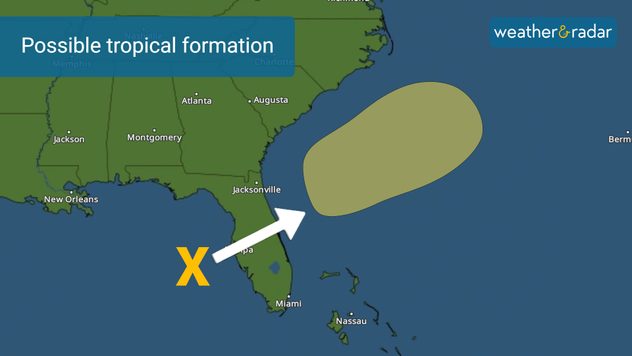
Chance of tropical formation within the next 7 days.

Periods of heavy rains have been affecting South Florida during the early morning hours and they will continue to fall through at least Wednesday morning. Flooding is possible.

This same deep tropical moisture that is impacting parts of Florida —and could bring big flood problems — has a low chance of developing in the season’s first tropical disturbance once it crosses over to the eastern Atlantic.

Once it crosses, it will be moving away from the East Coast and likely be absorbed by a front exiting the U.S. So, not much to worry there about formation.

This same system is not organized and it could still bring over a foot of rain for some places across Southwest Florida through the next 2 days.

Lots of moisture is being pulled from the south right over South Florida. Persistent rainbands could bring 15 inches of rain, especially across southwestern Florida.

Across Southeastern Florida, places between Miami Dade, Broward, and Palm Beach could reach up to 10 inches of rain, but generally, there will be between 4-6 inches of rain through Thursday morning.

There will be big variations across Central Florida. The Tampa Bay area is likely to receive 6 to 8 inches of rain, while cities in Orange County, where the city of Orlando is located, could be some areas with 3 inches and the southern fringe of the county could get 6 inches.

Please avoid flood waters, walking or driving through them. Waters could be contaminated and deeper than expected. Displaced animals and sharp objects could also be hidden in them.

Irene Sans
More on the topic
High pressure & extreme heat. Why & how does it work?. . . Sunday, July 12, 2026
Sunday, July 12, 2026

Why & how does it work?

High pressure & extreme heat
How does fog form?. Multiple ways. . . Saturday, July 11, 2026
Saturday, July 11, 2026

Multiple ways

How does fog form?
Hurricane parade in the Pacific. Karina is very strong. . Weather Videos. Tuesday, September 1, 2026
WindRadar for Friday, showing the three hurricanes – Lowell, Karina and Maria – over the Pacific.
Weather VideosTuesday, September 1, 2026

Karina is very strong

Hurricane parade in the Pacific
All weather news
This might also interest you
What is it, and why is it important?. North American Monsoon. . . Sunday, September 6, 2026
Desert thunderstorm
Sunday, September 6, 2026

North American Monsoon

What is it, and why is it important?
Useful tips when driving in the rain. Flood safety. . . Sunday, August 30, 2026
Sunday, August 30, 2026

Flood safety

Useful tips when driving in the rain
Northwest chilly showers. Autumn premiere. . . Thursday, September 3, 2026
A cooler Northwest
Thursday, September 3, 2026

Autumn premiere

Northwest chilly showers
All articles
Weather & Radar

Weather & Radar is also available on

Google Play StoreApp Store

Company

Contact us Privacy policy Legal info Accessibility statement

Services

Uploader

Socials

instagramfacebookthreadslinkList