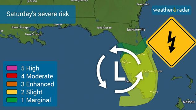
Home / Editor's Pick /

Tropical storm-like: Tornadoes, gusts & flood possible

07:08 PM
December 15, 2023

Tropical storm-like
Tornadoes, gusts & flood possible

Recommended external content from YouTube

We need your consent to show content from YouTube. You can withdraw your consent at any time.

I agree that content from YouTube will be displayed to me.

Settings for external content

Privacy policy

SUMMARY FOR FLORIDA:

The storm will dissect the Florida peninsula, bringing severe conditions, then emerge over the eastern Atlantic. Once east of Florida, colder, drier air will slowly filter over Georgia and Florida, and the weather will gradually improve early next week.

We are forecasting an active weekend, starting in Florida, where the risk of severe storms including the possibility of tornadoes will be present on Saturday. Have multiple ways to receive weather alerts.

The greatest risk will be the possible development of tornadoes over central Florida on Saturday night and early Sunday morning.The greatest risk will be the possible development of tornadoes over central Florida on Saturday night and early Sunday morning.

As South Florida continues to deal with lots of clouds and showers, the situation is about to get worse and expand all over the state. A low-pressure system, inches closer to the state at the end of the week and is likely to bring tropical storm-like conditions throughout the weekend.

This storm is likely to gain strength as it moves over the eastern Gulf of Mexico, so the Florida Peninsula should prepare for a very rainy Saturday, with gusts that could exceed 60 mph. The biggest concern is the possibility of tornadoes forming and it is more serious because these tornadoes would form at nighttime. It is important that you have several ways to receive tornado warnings. Remember that a tornado warning means that a tornado has been detected, by radar or visually, and you should go to a safe location at your home or work.

What will happen after it crosses Florida?

The Carolinas through the Mid-Atlantic will be dealing with dangerous weather early next week. The main hazards will be wind, heavy rains, and dangerous seas and surf. It is possible for the center of this storm to border the Georgia/South Carolina coast and move inland, but while it is bordering these states very dangerous storm surge could affect the entire coast of South and North Carolina on Sunday.

By Monday, the center of the storm will be approaching the Northeast, but the winds will then swing around and be mainly from the north-northwest on Monday for Georgia, Florida and the Carolinas.

How much rain?

South Florida will be the bullseyes, with around 8 inches still possible throughout this entire event. Let’s remember that rain has been battering the area since Wednesday and will continue until late Saturday. The rest of the Peninsula could receive around 4 inches with some isolated spots with higher amounts.

Once the storm crosses Florida and advances over the Carolinas and the Mid-Atlantic states, precipitation could also be high, causing flash flooding. For now, the forecast indicates that accumulations in the Carolinas may also approach 8 inches in isolation. The Florida Panhandle, Georgia, and South Carolina could see more than 5 inches of rain through Monday night. Virginia, northern North Carolina, and Maryland could receive between 3 and 5 inches, as the system is expected to be moving quicker at this point.

With heavy rain, especially in areas soaked by recent rains, flash flooding could develop. Please avoid crossing flooded areas. Turn around, don't drown.

Secure outdoor loose objects and decorations!

The winds will be strong as the system comes closer to Florida on Friday and Saturday. In fact, winds have been blowing strongly on Thursday, with gusts that have reached 30 mph at Miami International Airport. Wind advisories are in effect until Sunday, as gusts could reach 45 mph. For Central and Northern Florida, gusts are also expected to be strong, reaching 50 mph at times.

Wind advisories will likely be issued for many more areas in Florida, Georgia, and the Carolinas by the end of the week and into the weekend. This storm could bring very strong gusts above 55 mph and sustained winds between 30 and 40 mph.

SAFETY TIP:

We understand that it takes lots of effort, but if you are in an area under wind advisories, you should consider bringing any Christmas decorations placed outdoors, as in the wind they can become projectiles, causing damage.

We will continue to monitor this system throughout the weekend and will be fully staffed to track the impacts of this event.

**This information, written by our meteorologists, is also available in Spanish using our app in this language or in tiempoyradar.com

Irene Sans
More on the topic
Saturday, April 26, 2025

Off the coast of Sardinia

Waterspout seen from cruise ship
Sleeping cat
Sunday, April 20, 2025

Seasonal tiredness

What causes spring fatigue?
Summer brings the heat and the water activities with it!
Monday, June 2, 2025

Bye, spring!

Meteorological summer is here!
All weather news
This might also interest you
Tuesday, June 17, 2025

Daily briefing

Big Plains storms
Monday, June 16, 2025

Trout Fire in N.M.

Smoke caught on our WeatherRadar
Monday, June 16, 2025

Daily briefing

Storms linger for East
All articles
Weather & Radar

www.weatherandradar.com

instagramfacebookthreadsContact uslinkList
Privacy policy | Legal info