Home
Weather New York
WeatherRadar
RainRadar
TemperatureRadar
WindRadar
LightningRadar
Weather News
Editor's Pick
Discover the app
Weather widget
Contact us
Apps
Career
    Home / Editor's Pick /

    Tropical update Sean: slowly weakens, tropical wave follows

02:55 PM
October 12, 2023

Tropical update
Sean slowly weakens, wave follows

It’s Thursday and we continue to monitor the tropics. Tropical Depression Sean loses energy and another tropical wave behind Sean seems to stay a bit more south. Let´s discuss.

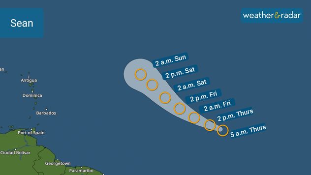
Sean, as we talked about on Wednesday, is losing strength and is no longer a tropical storm and just a depression. It is slated to continue battling strong wind shear throughout the weekend, and although the forecast calls for Sean to remain as a tropical depression over the open central Atlantic waters, I would not be surprised if Sean completely vanishes at some point before the weekend ends. Sean beat a record as the farthest east a tropical storm has formed in the Atlantic so late in the calendar year.

Sean's track issued by the NHC on Thursday morning.

It is incredible to think that we have El Niño and the Atlantic hurricane season continues to produce tropical systems, especially tropical systems still coming out from Africa.

The next tropical wave located about 700 miles east-southeast of Sean and closer to the African coast, will continue to move eastward. It has a 30 percent chance of developing into a tropical system within the next 7 days. According to the latest graphic by the National Hurricane Center, it is possible for this system to develop in a lower latitude than Sean, below 15 deg North. If this is verified, the Caribbean will have to monitor this storm closely. The good news is that there is plenty of time to watch its evolution and it will likely not be an issue for the Caribbean for a while.

We will continue to monitor the tropics and bring you prompt updates. We are also monitoring weather across the United States. Cloud coverage will become crucial to monitor this Saturday as there will be a solar annular eclipse happening, and the entire contiguous U.S. will experience at least a partial eclipse. You can read the latest on this amazing event here.

Irene Sans
More on the topic
Rip currents & safety tips. As more head to the coast. . . Saturday, July 25, 2026
rip current
Saturday, July 25, 2026

As more head to the coast

Rip currents & safety tips
Meteorological summer is here!. Bye, spring!. . . Monday, June 1, 2026
Monday, June 1, 2026

Bye, spring!

Meteorological summer is here!
Super Typhoon Near the Philippines. Gusts up to 155. . . Tuesday, June 23, 2026
Tuesday, June 23, 2026

Gusts up to 155

Super Typhoon Near the Philippines
All weather news
This might also interest you
Thunderstorms: Anywhere. Anytime.. How do they form?. . . Sunday, August 2, 2026
Sunday, August 2, 2026

How do they form?

Thunderstorms: Anywhere. Anytime.
Three common misperceptions. Hurricane season. . . Sunday, August 2, 2026
Hurricane Ian (2022) satellite imagery before SWFL landfall.
Sunday, August 2, 2026

Hurricane season

Three common misperceptions
Wildfire smoke on the WeatherRadar. Air quality concerns. . . Tuesday, August 4, 2026
Tuesday, August 4, 2026

Air quality concerns

Wildfire smoke on the WeatherRadar
All articles
Weather & Radar

Weather & Radar is also available on

Google Play StoreApp Store

Company

Contact us Privacy policy Legal info Accessibility statement

Services

Uploader

Socials

instagramfacebookthreadslinkList