Home
Weather New York
WeatherRadar
RainRadar
TemperatureRadar
WindRadar
LightningRadar
Weather News
Editor's Pick
Discover the app
Weather widget
Contact us
Apps
Career
    Home / Editor's Pick /

    Tropical update: Storm threatens Texas, fired up Atlantic

03:26 PM
August 21, 2023

Tropical update
Storm threatens Texas, fired up Atlantic

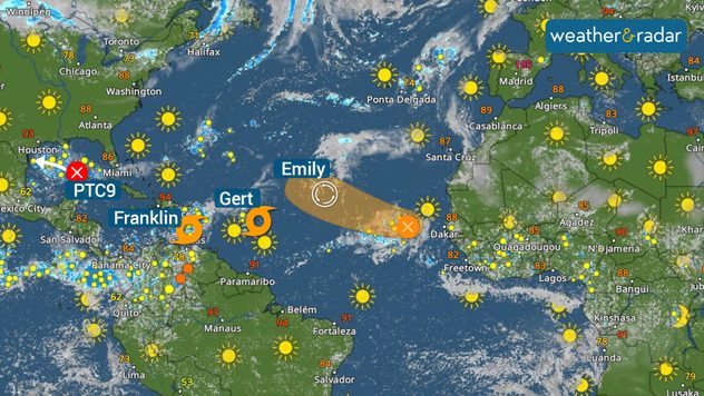
For the second consecutive day, another tropical storm is named in the Atlantic. This time we have Franklin in the Caribbean, Gert just east of the Lesser Antilles, and Emily, which will just keep on swimming, just keep swimming (sing it!). Closer, we now have Potential Tropical Cyclone 9, threatening southern Texas, and another tropical wave!

Atlantic is fired up!!

Let's start with Potential Tropical Cyclone 9, the robust tropical wave brewing in the Gulf of Mexico. it is moving west and there are tropical storm warning in effect for the South Texas coast. Remember Potential Tropical Cyclone means that the system has a high chance of becoming a tropical system, just doesn´t have the characteristic just yet, but it is so close to land that the National Hurricane Center labels it as such because residents need to be warned and authorities need to start being activated and preparing citizens. Special awareness for the Southern Texas and northern Mexico coast, as this system (likely Harold) is forecast to impact the region on Tuesday.

Franklin heading to the Hispaniola

Tropical Storm Franklin formed on Sunday afternoon. A tropical storm warning is now in effect for the southern coast of Haiti and the Dominican Republic, and a tropical watch is now in effect for the northern coast.

Franklin has 50 mph maximum sustained winds and is moving west at 12 mph. Franklin will be stomping on the brakes later on Monday as it prepares to make a turn to the north on Tuesday. This break will bring constant heavy rains to the central islands of the Caribbean. Between 2 to 4 inches of rain are possible, but some areas can get up to 6 in Puerto Rico. While in the DR and Haiti, up to 12 inches of rain can accumulate. Pay attention to our updates.

Franklin could be a strong tropical storm, near hurricane status before making landfall on Tuesday night near Barahona in the Dominican Republic. It will travel through the highest mountains in the Caribbean and exit quickly over the Atlantic waters. This system could intensify once again later this week, but it is expected to remain over the open central Atlantic.

Tropical Storm Gert

Monday’s newest storm is Gert. This was tropical depression 6 over the weekend and it briefly intensified this morning, therefore the NHC decided to baptize it. Luckily, it will not last too long. It is still expected to enter a hostile environment just before approaching the northeastern Caribbean, which will end its tropical depression life late Monday night.

Post-Tropical Storm Emily

Emily has lost strength, now a post-tropical cyclone, and will continue to do so as it moves over the central Atlantic waters. It is moving very slowly. No threat to land.

Tropical wave in far Eastern Atlantic

Finally, the last tropical wave. It is located near the Cabo Verde Islands. It is expected to become better organized and acquire a name (maybe Idalia, if nothing else pops up before). Luckily this system is forecast to follow Emily’s footsteps and remain over the open Atlantic waters.

Our team of meteorologists is closely watching PTC 9 and the rest of the tropics. We will be bringing you updates about the threats this system will bring to help you make the safest decisions. **This same information can be seen in Spanish, written by our bilingual meteorologists if your phone is set to Spanish and using our app too. Tell your family and friends that only speak Spanish so that they can also be informed and stay safe, please.**

Irene Sans
More on the topic
Hurricane Polo remains dangerous. Active Pacific. . . Thursday, September 24, 2026
Thursday, September 24, 2026

Active Pacific

Hurricane Polo remains dangerous
What are weather fronts?. Weather explained. . . Sunday, August 23, 2026
Image of a temperature radar showing a clear distinction between a warm and cold air mass separated by a cold front.
Sunday, August 23, 2026

Weather explained

What are weather fronts?
Record ocean heat halting hurricanes. Strong El Niño influence. . . Sunday, September 13, 2026
A weather map shows a calm Atlantic Ocean with no hurricanes, alongside a picture of the sea.
Sunday, September 13, 2026

Strong El Niño influence

Record ocean heat halting hurricanes
All weather news
This might also interest you
Beautiful autumn sky. Your weather — Your shots. . . Saturday, September 19, 2026
Saturday, September 19, 2026

Your weather — Your shots

Beautiful autumn sky
30-degree drop on heels of equinox. Mid-Atlantic & Southeast. . . Monday, September 21, 2026
Monday, September 21, 2026

Mid-Atlantic & Southeast

30-degree drop on heels of equinox
High winds whip East Coast. Nor'easter spins offshore. . . Friday, September 25, 2026
Friday, September 25, 2026

Nor'easter spins offshore

High winds whip East Coast
All articles
Weather & Radar

Weather & Radar is also available on

Google Play StoreApp Store

Company

Contact us Privacy policy Legal info Accessibility statement

Services

Uploader

Socials

instagramfacebookthreadslinkList