Home
Weather New York
WeatherRadar
RainRadar
TemperatureRadar
WindRadar
LightningRadar
Weather News
Editor's Pick
Discover the app
Weather widget
Contact us
Apps
Career
    Home / Editor's Pick /

    Tropical update: Wave uncertainty & Gulf formation?

04:19 PM
August 17, 2023

Tropical update
Wave uncertainty & Gulf formation?

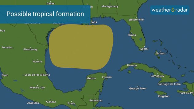
There is a low chance for a tropical system to develop by early next week over the Gulf of Mexico.

The probability of the tropical waves over the far eastern Atlantic continues to grow but our eyes are monitoring the possible evolution of a tropical system in the Gulf of Mexico that could potentially move toward the U.S.

The area of possible development over the Gulf of Mexico has a 30 percent chance of developing in the next 7 days. There are signs that there could be a loosely compact area of low pressure that could develop by Sunday, but there are other models that show no real formation until Tuesday. We are likely not referring to a full-fledged system like a hurricane, but likely a tropical depression or tropical storm. Remember, when and if something does develop, it will be close to land, so residents should prepare ahead of time.

Without a well-defined center of circulation, there is no way of knowing where a system could move.

The two tropical waves still traveling from the far eastern Atlantic have both now increased their chances of formation within the next 7 days to 60 percent. The future of these waves continues to point to the second one (closer to Africa) staying over water and moving northward. While the first one will struggle to grow stronger due to dry air around it.

We will be staffed during the weekend to update you on the tropics. Our Task Force will be activated as soon as the U.S. is under a tropical watch.

Irene Sans
More on the topic
Rip currents & safety tips. As more head to the coast. . . Saturday, July 25, 2026
rip current
Saturday, July 25, 2026

As more head to the coast

Rip currents & safety tips
High pressure & extreme heat. Why & how does it work?. . . Sunday, July 12, 2026
Sunday, July 12, 2026

Why & how does it work?

High pressure & extreme heat
Super Typhoon Near the Philippines. Gusts up to 155. . . Tuesday, June 23, 2026
Tuesday, June 23, 2026

Gusts up to 155

Super Typhoon Near the Philippines
All weather news
This might also interest you
Lopsided Bertha moves west. Who sees the impacts. . . Thursday, July 23, 2026
Thursday, July 23, 2026

Who sees the impacts

Lopsided Bertha moves west
When severe storms strike.... You can be ready. . . Sunday, July 26, 2026
Sunday, July 26, 2026

You can be ready

When severe storms strike...
Multi-Day flood threat for Mid-Atlantic. Stalled front. . . Wednesday, July 22, 2026
Wednesday, July 22, 2026

Stalled front

Multi-Day flood threat for Mid-Atlantic
All articles
Weather & Radar

Weather & Radar is also available on

Google Play StoreApp Store

Company

Contact us Privacy policy Legal info Accessibility statement

Services

Uploader

Socials

instagramfacebookthreadslinkList