Home
Weather New York
WeatherRadar
RainRadar
TemperatureRadar
WindRadar
LightningRadar
Weather News
Editor's Pick
Discover the app
Weather widget
Contact us
Apps
Career
    Home / Weather News /

    Tuesday's live blog: Severe storms and flooding target Texas

09:31 PM
May 28, 2024

Tuesday's live blog
Severe storms and flooding target Texas

Powerful storms are targeting the Lone Star State, with dangerous storms rolling across western Texas. Track them .

5 p.m. CDT

As our WeatherRadar shows storms continue to fire across western Texas. These will continue through the tonight.

4:15 p.m. CDT

It has been a wild day across Texas as storms hit Dallas earlier and hitting Houston within past several hours.

This was from earlier in Dallas:

While, in Houston, power was flickering in a newsroom when storms arrived:

4:00 p.m. CDT

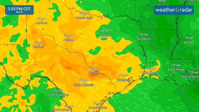
Gusty winds across portions of Texas and Louisiana will continue, both in and outside of thunderstorms. Keep an eye on gusts with our WindRadar.

WindRadar

3:00 p.m. CDT

The WeatherRadar shows heavy downpours slamming the Texas and Louisiana coastlines. More than one million customers are without power in Texas, with 20,000 without power now in Louisiana.

2:00 p.m. CDT

Power outages continue to impact Texas. More than 962,000 customers are without power across the Lone Star State as of this update.

1:00 p.m. CDT

Parts of central Texas have been removed from the enhanced risk, however, there is still the threat of strong storms and flash flooding in this area. Stay alert!

12:00 p.m. CDT

Storms capable of producing damaging winds will move into parts of Louisiana over the next few hours. Strong storms continue to impact parts of eastern Texas.

11:00 a.m. CDT

Outflow boundaries will have a significant impact on where storms develop later this morning and into the afternoon. Keep an eye on the WeatherRadar for the latest.

10:15 a.m. CDT

Flooding is also a significant concern today. A moderate risk, a level 3 out of 4, of excessive rain is in place across central Texas today. Remember to turn around, don't drown, if you come across water on the road.

9:30 a.m. CDT

Nearly 800,000 customers are without power this morning in northeast Texas as strong storms work through the region. Keep an eye on the WeatherRadar today. Much of Texas is under an enhanced risk, a level 3 out of 5, of severe storms today.

More on the topic
Super Typhoon Bavi threatens Taiwan. 155 mph winds. . Weather Videos. Wednesday, July 8, 2026
The image shows an intense tropical cyclone over the western Pacific, east of Taiwan and the Philippines. The centre of the system is depicted as a light purple and white vortex with a clearly visible eye, surrounded by a ring of red and orange areas indicating the strongest wind speeds. A white arrow marks the typhoon’s predicted track towards the north-west, in the direction of Taiwan. To the west of the storm lie the Philippines, with the cities of Manila and Cebu; to the north of these lies Taiwan, with Taipei. Further west, the Chinese coast, including Hong Kong, and parts of Vietnam can be seen. The coloured wind map shows predominantly green areas outside the storm’s core, indicating significantly weaker winds. White streamlines illustrate the typhoon’s anti-clockwise circulation in the Northern Hemisphere. The highest wind speeds are concentrated around the eye of the cyclone.
Weather VideosWednesday, July 8, 2026

155 mph winds

Super Typhoon Bavi threatens Taiwan
Waterspouts possible, what are they?. They can be dangerous. . . Sunday, August 9, 2026
Waterspouts weatherradar.
Sunday, August 9, 2026

They can be dangerous

Waterspouts possible, what are they?
Record-breaking heatwave in Europe. Hotter than most of U.S.. . . Thursday, June 25, 2026
Thursday, June 25, 2026

Hotter than most of U.S.

Record-breaking heatwave in Europe
All weather news
This might also interest you
Downbursts: Why are they dangerous?. Torrential downpour. . . Saturday, August 15, 2026
Downburst shown on the WeatherRadar.
Saturday, August 15, 2026

Torrential downpour

Downbursts: Why are they dangerous?
Gravity wave spotted on WeatherRadar. Moving into TN. . . Monday, August 17, 2026
Monday, August 17, 2026

Moving into TN

Gravity wave spotted on WeatherRadar
Days of record nighttime heat. Feeling tropical. . . Monday, August 17, 2026
Monday, August 17, 2026

Feeling tropical

Days of record nighttime heat
All articles
Weather & Radar

Weather & Radar is also available on

Google Play StoreApp Store

Company

Contact us Privacy policy Legal info Accessibility statement

Services

Uploader

Socials

instagramfacebookthreadslinkList