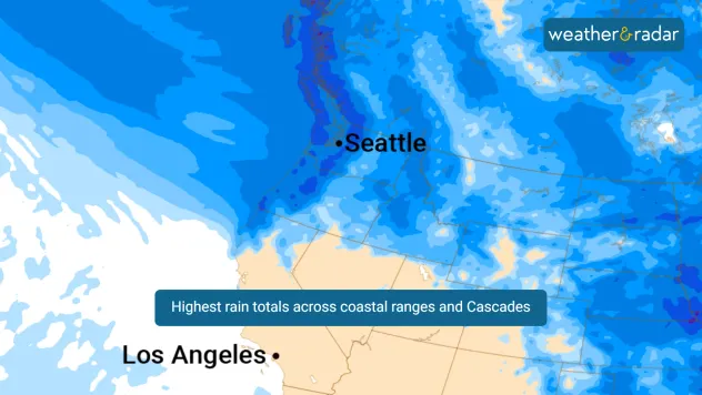
Home
Weather New York
WeatherRadar
RainRadar
TemperatureRadar
WindRadar
LightningRadar
Weather News
Editor's Pick
Discover the app
Weather widget
Contact us
Apps
Career
Home / Weather News /

Unusual wet pattern set to dampen weekend plants across the Pacific Northwest

04:18 PM
May 31, 2024

Atmospheric river pattern
Unusual Rainfall in Pacific Northwest

rainfall totals pacific northwest

A late-season atmospheric river-style system will bring a period of unusually wet weather across the Pacific Northwest this weekend into early next work week.

The culprit is an atmospheric river pattern, which is more typical of the winter months. The heaviest rainfall will occur Sunday night into Monday morning across the Southwest Olympics, coastal mountain ranges, and the Cascades. Several rivers may approach action levels, with minor flood impacts possible. Fortunately, the risk for flash flooding or debris flows remains at the low end, near 5%.

This is not your typical late-spring weather. The wet season in Washington state typically runs from October through April. During this period, the state experiences the majority of its annual rainfall, with the heaviest precipitation usually occurring in the winter months of November, December, and January.

HeaderHeader
Portland, Ore.60%
Salem, Ore.67%
Eugene, Ore.61%
Sea-Tac, Wash.30%
Tacoma, Wash.42%
Olympia, Wash.53%

The western part of Washington, particularly the coastal regions and areas near the Olympic Mountains and the Cascade Range, receives significantly more rainfall compared to the eastern part of the state. The atmospheric river pattern amplifies this, leading to heavy rainfall and potential minor flooding, especially during the peak of the wet season.

Federico Di Catarina
More on the topic
Saturday, February 21, 2026

Find the lotion!

Dry skin season is back
Attention not translate yet!Tuesday, January 20, 2026

Amazing photos last night

Auroras still possible tonight
pothole repair
Sunday, February 15, 2026

Bumpy commute

Cold = spring potholes
All weather news
This might also interest you
Monday, February 23, 2026

Heavy snow accumulates

Blizzard strikes Northeast
Wintry weather impacts D.C. on the WeatherRadar.
Sunday, February 22, 2026

Snow, sleet or ice

How atmospheric temps shape winter precipitation
Wednesday, February 25, 2026

Fire danger grows

Rockies, N. Plains high wind threat
All articles
Weather & Radar
US
Clima & Radar Brasil
Hava durumu & Radar Türkiye
Időjárás és Radar Magyarország
Καιρός & Ραντάρ Ελλάδα
Météo & Radar Belgique (Français)
Météo & Radar France
Meteo & Radar Italia
Meteo & Radar România
Météo & Radar Suisse (Français)
Meteo & Radars Latvija
OrasOnline Lietuva
Počasí & Radar Czechia
Počasie & Radar Slovensko
Pogoda & Radar Polska
Погода & Радар Україна (українська)
Tempo & Radar Portugal
Tiempo & Radar Argentina
Tiempo & Radar España
Vejr & Radar Danmark
Vreme & Radar Slovenija
Vreme & Radar Srbija
Vrijeme & Radar Bosna
Vrijeme & Radar Crna Gora
Vrijeme & Radar Hrvatska
Време & Радар България
Времето & Радар Macedonia
Weather & Radar India (English)
Weather & Radar Ireland
Weather & Radar United Kingdom
Weather & Radar USA (Español)
Weer & Radar België (Nederlands)
Weer & Radar Nederland

Weather & Radar is also available on

Google Play StoreApp Store

Company

Contact us Privacy policy Legal info Accessibility statement

Services

Uploader

Socials

instagramfacebookthreadslinkList