Home
Weather New York
WeatherRadar
RainRadar
TemperatureRadar
WindRadar
LightningRadar
Weather News
Editor's Pick
Discover the app
Weather widget
Contact us
Apps
Career
    Home / Weather News /

    Up to 6 inches - Flooding rains stay focused on South

03:18 PM
June 22, 2026

Up to 6 inches
Flooding rains stay focused on South

More than a month's worth of rain could accumulate in northern Arkansas, northwest Mississippi and southwestern Tennessee on Monday. Up to 3 inches of rain per hour could fall in this focus area, while isolated flash flooding could occur along the Front Range through the southern tier and northward into the Northeast, too.

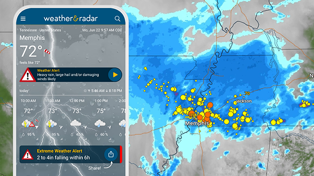
A moderate risk - a level three out of four - for flash flooding is forecast for parts of the lower Mississippi Valley on Monday as a mesoscale convective system (MCS) moves through. Normally, Memphis receives up to 4 inches of rain in June. Today, the city and surrounding suburbs could receive that and then some.

Mesoscale convective system

A large cluster of heavy rain and thunderstorms that could cause damaging winds and flash flooding.

Heavy rain alerts are active on the Weather & Radar app today, notifying residents of the significant rainfall. These alerts are available for everything from rain and thunderstorms to snowstorms and tropical systems.

WeatherRadar: Flooding rains are impacting portions of the southern U.S. on Monday. Weather alerts are active.

Flash flooding is already occurring in northern Arkansas, where 3 to 6 inches have piled up on Monday morning, even during the commute. The MCS is moving farther south and feeding off the warm, water-laden air mass provided by the Gulf.

You can track the wet and stormy weather on the WeatherRadar and get alerted through our notifications when impactful weather is drawing near.

Upload your weather views to the appread more
Becca Parker
More on the topic
Rip currents & safety tips. As more head to the coast. . . Saturday, July 25, 2026
rip current
Saturday, July 25, 2026

As more head to the coast

Rip currents & safety tips
Record-breaking heatwave in Europe. Hotter than most of U.S.. . . Thursday, June 25, 2026
Thursday, June 25, 2026

Hotter than most of U.S.

Record-breaking heatwave in Europe
Europe: Warmest June on record. Warm waters too. . . Friday, July 10, 2026
The record-breaking heatwave in June has made climate history in Western Europe.
Friday, July 10, 2026

Warm waters too

Europe: Warmest June on record
All weather news
This might also interest you
August starts blazing hot. Weekend preview. . . Thursday, July 30, 2026
Triple digit Saturday for the Mountain West.
Thursday, July 30, 2026

Weekend preview

August starts blazing hot
Big 50-degree jump. Northwest heat extremes. . . Thursday, August 6, 2026
Big temperature jumps
Thursday, August 6, 2026

Northwest heat extremes

Big 50-degree jump
Thunderstorms: Anywhere. Anytime.. How do they form?. . . Sunday, August 2, 2026
Sunday, August 2, 2026

How do they form?

Thunderstorms: Anywhere. Anytime.
All articles
Weather & Radar

Weather & Radar is also available on

Google Play StoreApp Store

Company

Contact us Privacy policy Legal info Accessibility statement

Services

Uploader

Socials

instagramfacebookthreadslinkList