Home
Weather New York
WeatherRadar
RainRadar
TemperatureRadar
WindRadar
LightningRadar
Weather News
Editor's Pick
Discover the app
Weather widget
Contact us
Apps
Career
    Home / Weather News /

    Volcano near Tonga erupts prompts tsunami warning from Alaska to Southern California

07:30 PM
January 15, 2022

Tsunami warning for West Coast
Hunga Tonga Hunga Ha’apai volcano erupts
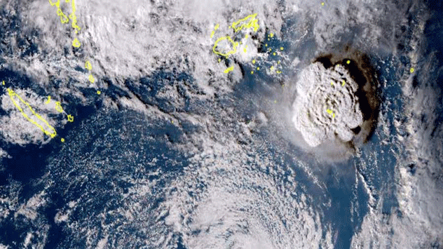
Hunga Tonga Hunga Ha’apai volcano erupts on January 15 around 5pm local Tonga time.

Saturday evening update:

The tsunami warning has been downgraded to a tsunami advisory for parts of the West Coast of the U.S. The only areas with a tsunami advisory are the Oregon-California border and from Davenport, California southward to Rincon Point, located about 14 miles southeast of Santa barbara.

Saturday Noon Update:

The Hunga Tonga Hunga Ha’apai volcano erupts on January 15 around 5 pm local time in Tonga, prompting a tsunami warning for the entire U.S. West Coast and Pacific Islands. Tsunami waves have been pushing boats onto docks in Hawaii and, as expected, are arriving on the West Coast on Saturday morning.

Privacy policy

A submarine volcano located near Tonga in the Southern Pacific region called Hunga Tonga Hunga Ha’apai volcano erupted on Saturday afternoon local time in Tonga. This last impressive explosion comes after a series of strong eruptions happening since December 2021. The volcano is located about 18.6 miles southeast of Tonga's Fonuafo'ou island.

There was a large explosion that began on January 14, which sent ash about 12 miles up in the air, prompting tsunami warnings for the Tonga residents.

The eruption of January 15 produced a mushroom-like explosion that launched ash about 11 miles up in the air, this time there are also advisories for airlines. There was a magnitude 4.0 earthquake registered in Tonga shortly after the eruption.

Tsunami warnings are in effect for the entire U.S. West coast.

Tsunami waves of between 3 and 4 feet stroke, Nuku’alofa, the capital of Tonga, as the ash clouds were also seen obscuring the sun. Pacific islands like Fiji, and American Samoa, have also registered small tsunami waves. The Vanuatu Islands recorded larger tsunami waves between 3 and 8 feet.

In Hawaii, tsunami waves have pushed boats out of the water and onto docks.

The entire west coast of the United States, from Alaska through Southern California is also under a tsunami warning as tsunami waves arrive in the area.

There have already been some small waves affecting parts of California as they were expected to arrive by 7 am on Saturday morning. Authorities expect the waves to peak between 1 to 2 feet. People are advised to avoid the beaches and any coastal areas or activities on Saturday.

Experts advise that residents in areas above 3 feet in elevation are safe. The warning is for the immediate coast and areas below 3 feet in elevation.

This is a developing story, and we will continue to bring your prompt updates throughout the day.

Irene Sans
More on the topic
Super Typhoon Near the Philippines. Gusts up to 155. . . Tuesday, June 23, 2026
Tuesday, June 23, 2026

Gusts up to 155

Super Typhoon Near the Philippines
Waterspouts possible, what are they?. They can be dangerous. . . Saturday, July 11, 2026
Waterspouts weatherradar.
Saturday, July 11, 2026

They can be dangerous

Waterspouts possible, what are they?
Super Typhoon Bavi threatens Taiwan. 155 mph winds. . Weather Videos. Wednesday, July 8, 2026
The image shows an intense tropical cyclone over the western Pacific, east of Taiwan and the Philippines. The centre of the system is depicted as a light purple and white vortex with a clearly visible eye, surrounded by a ring of red and orange areas indicating the strongest wind speeds. A white arrow marks the typhoon’s predicted track towards the north-west, in the direction of Taiwan. To the west of the storm lie the Philippines, with the cities of Manila and Cebu; to the north of these lies Taiwan, with Taipei. Further west, the Chinese coast, including Hong Kong, and parts of Vietnam can be seen. The coloured wind map shows predominantly green areas outside the storm’s core, indicating significantly weaker winds. White streamlines illustrate the typhoon’s anti-clockwise circulation in the Northern Hemisphere. The highest wind speeds are concentrated around the eye of the cyclone.
Weather VideosWednesday, July 8, 2026

155 mph winds

Super Typhoon Bavi threatens Taiwan
All weather news
This might also interest you
Ring of fire developing. Storms encircle heat. . . Wednesday, July 1, 2026
Wednesday, July 1, 2026

Storms encircle heat

Ring of fire developing
Saharan dust to reach Florida. Dry period expected. . . Tuesday, July 7, 2026
Saharan dust seen on the satllite image (right) moving westward toward Florida. Air quality impacts are expected.
Tuesday, July 7, 2026

Dry period expected

Saharan dust to reach Florida
Hotter in Detroit than Miami. Heatwave begins. . . Tuesday, June 30, 2026
Tuesday, June 30, 2026

Heatwave begins

Hotter in Detroit than Miami
All articles
Weather & Radar

Weather & Radar is also available on

Google Play StoreApp Store

Company

Contact us Privacy policy Legal info Accessibility statement

Services

Uploader

Socials

instagramfacebookthreadslinkList