Home
Weather New York
WeatherRadar
RainRadar
TemperatureRadar
WindRadar
LightningRadar
Weather News
Editor's Pick
Discover the app
Weather widget
Contact us
Apps
Career
    Home / Weather News /

    Warming trend and soggy East

10:00 AM
December 9, 2024

Breakfast Brief
Warming trend and soggy East

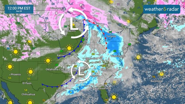
The weekend warming trend continues to start the week as another front approaches from the west. The Breakfast Brief is published every Monday through Friday at 5 a.m. ET.

The stretch of cold weather ended late this weekend across many areas in the South and East. Above-average temperatures will dominate the Southeast and southern central Plains to start the week. The warmest temperatures on Monday afternoon will likely happen across South Texas, where the mid-80s will be the norm. South Florida will reach the low 80s. See your TemperatureRadar.

The next storm systems will affect the East this week, but first, a warming trend ahead of them.

Chicago will be 'toasty' for this time of year's standards, reaching the low 50s in the afternoon, which is about 5 degrees above normal for this time of year. The Northeast, including Boston and NYC, will stay in the mid- to upper-40s. Expect the warming trend to continue on Tuesday, but colder air will begin to move east and take over the Midwest and Great Lakes. The Central Plains, including DFW, will move to below-average temperatures.

Across the West, temperatures will be everywhere. Slightly warmer than average temperatures are forecast for the California coast and valleys. The Sierras and Rockies will have temperatures between 5 and 15 degrees below average. Snow will likely affect parts of Wyoming, the Dakotas and Colorado, but this snowfall will taper off as the system moves east and high pressure sinks in, allowing for more stable conditions to start.

Lowest temp is just after sunriseread more

News we are covering today:

  • Soggy East
  • Warm temps

Did you miss these?

Watch: Shaking in Californiaread more

App news & updates:

As you prepare to plan your vacation or have plans to travel for the holidays, your chosen location might be the mountains. If you are hitting the slopes, we can help!

Irene Sans
More on the topic
Hurricane Polo remains dangerous. Active Pacific. . . Thursday, September 24, 2026
Thursday, September 24, 2026

Active Pacific

Hurricane Polo remains dangerous
Hawaii's second 2026 hurricane impact. Hurricane Lowell. . . Tuesday, September 8, 2026
Tuesday, September 8, 2026

Hurricane Lowell

Hawaii's second 2026 hurricane impact
Meteorological vs astronomical autumn. Season start date. . . Tuesday, September 1, 2026
Tuesday, September 1, 2026

Season start date

Meteorological vs astronomical autumn
All weather news
This might also interest you
Merging storms to bring record rain. Southwest, Plains. . . Tuesday, September 29, 2026
Heavy rainfall is expected across the Plains and Southwest, with flash flooding possible.
Tuesday, September 29, 2026

Southwest, Plains

Merging storms to bring record rain
Hawaii's busy hurricane season. Nolo could set record. . . Thursday, September 24, 2026
Hawaii troubles
Thursday, September 24, 2026

Nolo could set record

Hawaii's busy hurricane season
Spring Tides: Flooding, Road Closures. Happening along coasts. . . Tuesday, September 29, 2026
Tuesday, September 29, 2026

Happening along coasts

Spring Tides: Flooding, Road Closures
All articles
Weather & Radar

Weather & Radar is also available on

Google Play StoreApp Store

Company

Contact us Privacy policy Legal info Accessibility statement

Services

Uploader

Socials

instagramfacebookthreadslinkList