Home
Weather New York
WeatherRadar
RainRadar
TemperatureRadar
WindRadar
LightningRadar
Weather News
Editor's Pick
Discover the app
Weather widget
Contact us
Apps
Career
    Home / Weather News /

    Wednesday's live blog: Severe threat stretchs from Texas to NY

03:32 PM
May 22, 2024

Wednesday's live blog
Severe threat stretchs from Texas to NY

More severe storms are expected on the heels of Tuesday's deadly tornado outbreak that impacted the Midwest. Damaging winds, tornadoes, large hail, and flash flooding threats extend from the Plains to the Great Lakes today. This live blog will have up-to-the-minute updates throughout the day.

Deadly twister flattens Greenfieldread more

4:00 p.m. CT

With intense storms developing in Texas, now is the time to turn on your Weather & Radar app alerts. Click the link below to learn how.

How to turn on your app alertsread more

3:00 p.m. CT

Severe storms are firing up from the Plains to the Northeast. A few tornadoes are possible in Texas.

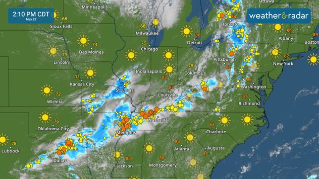
2:10 p.m. CT

Storms extend from Texas to New York on the WeatherRadar. Keep an eye on conditions in your area.

WeatherRadar

1:00 p.m. CT

A tornado watch is now in effect for parts of north and central Texas through 8 p.m. CT. Conditions are favorable for tornado development. Now is a good time to make sure your Weather & Radar app alerts are turned on.

12:00 p.m. CT

Flash flooding is also a concern today, with a slight risk (a level 2 out of 5) of excessive rain in effect across northern Texas, southern Oklahoma, and Arkansas.

11:00 a.m. CT

The WeatherRadar shows strong storms erupting across the central Plains and over the lower Great Lakes.

10:00 a.m. CT

Severe storms are once again a threat for millions today. The threat of strong storms extends from Texas to New York, with the greatest risk of severe weather stretching from central Texas into Arkansas.

More on the topic
Super Typhoon Bavi threatens Taiwan. 155 mph winds. . Weather Videos. Wednesday, July 8, 2026
The image shows an intense tropical cyclone over the western Pacific, east of Taiwan and the Philippines. The centre of the system is depicted as a light purple and white vortex with a clearly visible eye, surrounded by a ring of red and orange areas indicating the strongest wind speeds. A white arrow marks the typhoon’s predicted track towards the north-west, in the direction of Taiwan. To the west of the storm lie the Philippines, with the cities of Manila and Cebu; to the north of these lies Taiwan, with Taipei. Further west, the Chinese coast, including Hong Kong, and parts of Vietnam can be seen. The coloured wind map shows predominantly green areas outside the storm’s core, indicating significantly weaker winds. White streamlines illustrate the typhoon’s anti-clockwise circulation in the Northern Hemisphere. The highest wind speeds are concentrated around the eye of the cyclone.
Weather VideosWednesday, July 8, 2026

155 mph winds

Super Typhoon Bavi threatens Taiwan
Rip currents & safety tips. As more head to the coast. . . Saturday, July 25, 2026
rip current
Saturday, July 25, 2026

As more head to the coast

Rip currents & safety tips
Record-breaking heatwave in Europe. Hotter than most of U.S.. . . Thursday, June 25, 2026
Thursday, June 25, 2026

Hotter than most of U.S.

Record-breaking heatwave in Europe
All weather news
This might also interest you
Useful tips when driving in the rain. Flood safety. . . Saturday, August 1, 2026
Saturday, August 1, 2026

Flood safety

Useful tips when driving in the rain
Thunderstorms: Anywhere. Anytime.. How do they form?. . . Sunday, August 2, 2026
Sunday, August 2, 2026

How do they form?

Thunderstorms: Anywhere. Anytime.
Low pressure brings wet weekend. Soggy East. . . Friday, July 31, 2026
Friday, July 31, 2026

Soggy East

Low pressure brings wet weekend
All articles
Weather & Radar

Weather & Radar is also available on

Google Play StoreApp Store

Company

Contact us Privacy policy Legal info Accessibility statement

Services

Uploader

Socials

instagramfacebookthreadslinkList