Home
Weather New York
WeatherRadar
RainRadar
TemperatureRadar
WindRadar
LightningRadar
Weather News
Editor's Pick
Discover the app
Weather widget
Contact us
Apps
Career
    Home / Weather News /

    What to do after a flood

03:18 PM
April 8, 2025

Ky. town underwater
What to do after a flood

Drone footage shows parts of Frankfort, Ky., underwater after the Kentucky River reached its second-highest crest on record. Here's what to do after a flood.

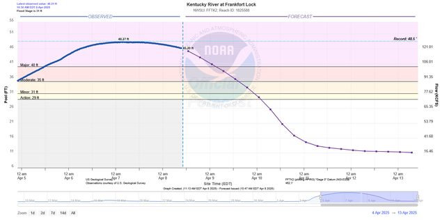
On Sunday, the Kentucky River crested at 48.27 ft, just shy of the record of 48.5 ft set in 1978. It will remain in major flood stage through early Wednesday, with waters slowly receding. Here's what to do after a flood impacts your area.

River flooding, slow-moving disasterread more

First, only return to your home or business after the local authorities give you the go-ahead. Floodwaters can hide many hazards, such as electrical lines, hazardous substances and wildlife. Next, do not drive or wade through floodwaters.

Floodwater is often contaminated with sewage, bacteria and other harmful materials. Avoid it as much as you can. Do not use floodwater for washing, bathing or any other purposes.

After the waters recede, stay cautious. Roads and foundations may have been weakened by the flooding. Also, keep an eye on your Weather & Radar app. Our WeatherRadar will show you if rain is on the way. Our advanced weather alert system will keep you up-to-date on the latest weather hazards in your area.

Learn about our alert system.read more
Mary Mays
More on the topic
Super Typhoon Near the Philippines. Gusts up to 155. . . Tuesday, June 23, 2026
Tuesday, June 23, 2026

Gusts up to 155

Super Typhoon Near the Philippines
Super Typhoon Bavi threatens Taiwan. 155 mph winds. . Weather Videos. Wednesday, July 8, 2026
The image shows an intense tropical cyclone over the western Pacific, east of Taiwan and the Philippines. The centre of the system is depicted as a light purple and white vortex with a clearly visible eye, surrounded by a ring of red and orange areas indicating the strongest wind speeds. A white arrow marks the typhoon’s predicted track towards the north-west, in the direction of Taiwan. To the west of the storm lie the Philippines, with the cities of Manila and Cebu; to the north of these lies Taiwan, with Taipei. Further west, the Chinese coast, including Hong Kong, and parts of Vietnam can be seen. The coloured wind map shows predominantly green areas outside the storm’s core, indicating significantly weaker winds. White streamlines illustrate the typhoon’s anti-clockwise circulation in the Northern Hemisphere. The highest wind speeds are concentrated around the eye of the cyclone.
Weather VideosWednesday, July 8, 2026

155 mph winds

Super Typhoon Bavi threatens Taiwan
Record-breaking heatwave in Europe. Hotter than most of U.S.. . . Thursday, June 25, 2026
Thursday, June 25, 2026

Hotter than most of U.S.

Record-breaking heatwave in Europe
All weather news
This might also interest you
Multi-Day flood threat for Mid-Atlantic. Stalled front. . . Wednesday, July 22, 2026
Wednesday, July 22, 2026

Stalled front

Multi-Day flood threat for Mid-Atlantic
Heat indices soaring. High humidity. . . Saturday, July 25, 2026
Saturday, July 25, 2026

High humidity

Heat indices soaring
Multi-day rain event ends soon. Southeast U.S.. . . Friday, July 24, 2026
Friday, July 24, 2026

Southeast U.S.

Multi-day rain event ends soon
All articles
Weather & Radar

Weather & Radar is also available on

Google Play StoreApp Store

Company

Contact us Privacy policy Legal info Accessibility statement

Services

Uploader

Socials

instagramfacebookthreadslinkList