Home
Weather New York
WeatherRadar
RainRadar
TemperatureRadar
WindRadar
LightningRadar
Weather News
Editor's Pick
Discover the app
Weather widget
Contact us
Apps
Career
    Home / Editor's Pick /

    Why & how does it work? High pressure & extreme heat

12:00 PM
July 12, 2026

Why & how does it work?
High pressure & extreme heat

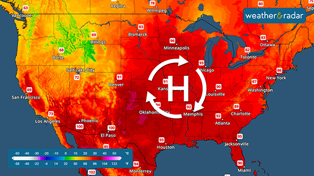
A high-pressure system in the upper atmosphere is to blame for the extreme heat that can occur in the summer.

Prolonged extreme temperatures are often due to the infamous dome of high pressure, which could stay in the same place for several days to a couple of weeks. Why do these pesky high pressures often bring so much heat for an extensive time? We got the answer for you!

Europe's record-breaking heatread more

High-pressure systems bring sinking air. The air dries and warms as it sinks, and with a blocking pattern, this heat can stay for several days or even weeks, keeping the A.C. running.

Temperatures increase in the eastern half as a high pressure settles in.

Keep an eye on the TemperatureRadar, especailly through these heatwaves, to know when the hottest part of the day will be. For some, nighttime relief will be hard to come by.

Irene Sans
More on the topic
Waterspouts possible, what are they?. They can be dangerous. . . Saturday, July 11, 2026
Waterspouts weatherradar.
Saturday, July 11, 2026

They can be dangerous

Waterspouts possible, what are they?
Heat wave setting records across Europe. London breaks May record. . . Tuesday, May 26, 2026
European heat wave
Tuesday, May 26, 2026

London breaks May record

Heat wave setting records across Europe
How does fog form?. Multiple ways. . . Saturday, July 11, 2026
Saturday, July 11, 2026

Multiple ways

How does fog form?
All weather news
This might also interest you
Slow-moving storms and heavy rain. What to look for. . . Monday, July 6, 2026
Monday, July 6, 2026

What to look for

Slow-moving storms and heavy rain
Northern New England storms. Rare severe threat. . . Tuesday, July 14, 2026
Tuesday, July 14, 2026

Rare severe threat

Northern New England storms
Saharan dust to reach Florida. Dry period expected. . . Tuesday, July 7, 2026
Saharan dust seen on the satllite image (right) moving westward toward Florida. Air quality impacts are expected.
Tuesday, July 7, 2026

Dry period expected

Saharan dust to reach Florida
All articles
Weather & Radar

Weather & Radar is also available on

Google Play StoreApp Store

Company

Contact us Privacy policy Legal info Accessibility statement

Services

Uploader

Socials

instagramfacebookthreadslinkList