Home
Weather New York
WeatherRadar
RainRadar
TemperatureRadar
WindRadar
LightningRadar
Weather News
Editor's Pick
Discover the app
Weather widget
Contact us
Apps
Career
    Home / Weather News /

    How atmospheric temperatures determine winter precipitation types

08:00 PM
February 1, 2026

Snow, sleet or ice
How atmospheric temps shape winter precipitation
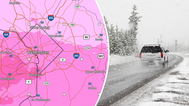
Wintry weather imacts D.C. on the WeatherRadar.
Wintry weather impacts D.C. on the WeatherRadar.

Winter weather isn't just about freezing temperatures at the surface; it's all about what's happening in the atmosphere above.

The type of precipitation we experience — whether it's snow, sleet, freezing rain, or rain — depends on the temperature layers the precipitation passes through as it falls. Each layer of air above us can have a different temperature, influencing whether precipitation stays frozen or melts before reaching the ground.

Here's how each type of winter precipitation is formed:

  • Snow forms when the entire column of air from the clouds to the surface is below freezing (32°F/0°C). The snowflakes remain frozen all the way down, giving us that powdery white blanket.
  • Sleet happens when snowflakes fall through a shallow warm layer (above freezing), partially melting, and then refreeze before hitting the ground. This creates tiny ice pellets that bounce off surfaces.
  • Freezing Rain starts as snow, but it travels through a deeper, warm layer and melts completely into rain. However, as it reaches the ground, it passes through a shallow freezing layer and freezes in contact with cold surfaces, creating a dangerous glaze of ice.
  • Rain occurs when temperatures remain above freezing from the clouds to the ground, preventing any freezing.


These different precipitation types are a result of the complex interplay between layers of warm and cold air in the atmosphere. So, next time you see snow or ice, remember — it's not just the temperature where you are, but what’s happening above your head that makes all the difference!

Try it out now!Wintry precipitation on the WeatherRadar
Federico Di Catarina
More on the topic
Hurricane parade in the Pacific. Karina is very strong. . Weather Videos. Tuesday, September 1, 2026
WindRadar for Friday, showing the three hurricanes – Lowell, Karina and Maria – over the Pacific.
Weather VideosTuesday, September 1, 2026

Karina is very strong

Hurricane parade in the Pacific
High pressure & extreme heat. Why & how does it work?. . . Sunday, July 12, 2026
Sunday, July 12, 2026

Why & how does it work?

High pressure & extreme heat
Meteorological vs astronomical autumn. Season start date. . . Tuesday, September 1, 2026
Tuesday, September 1, 2026

Season start date

Meteorological vs astronomical autumn
All weather news
This might also interest you
More than 20 inches of rain from Edouard. Possible drought help?. . . Thursday, September 3, 2026
Thursday, September 3, 2026

Possible drought help?

More than 20 inches of rain from Edouard
Dry vegetation, low humidity and winds. The perfect fire recipe. . . Saturday, September 5, 2026
Saturday, September 5, 2026

The perfect fire recipe

Dry vegetation, low humidity and winds
Why are some sunsets so beautiful?. And why are some duds?. . . Sunday, September 6, 2026
Credit Mark Maxwell - St Joseph, Mich.
Sunday, September 6, 2026

And why are some duds?

Why are some sunsets so beautiful?
All articles
Weather & Radar

Weather & Radar is also available on

Google Play StoreApp Store

Company

Contact us Privacy policy Legal info Accessibility statement

Services

Uploader

Socials

instagramfacebookthreadslinkList