Home / Weather News /

Storms for the Midwest, Breakfast Brief

09:00 AM
September 19, 2024

Breakfast Brief
Stormy Upper Midwest

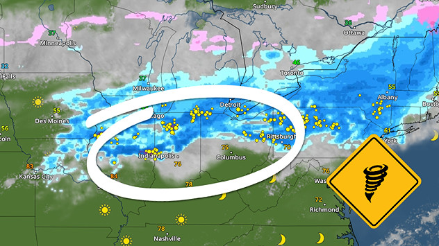
The country continues to be bisected by a cold front, with cooler-than-average temperatures to the west and warmer-than-average temperatures to the east. This same cold front will bring a severe threat to the Midwest.

The WeatherRadar shows a cold front dominating the central part of the U.S. This front stretches from the Upper Midwest into the Central Plains and will bring the risk of strong storms from Oklahoma to Wisconsin. Damaging wind, large hail and even a few tornadoes are possible in cities like Duluth and Minneapolis, Minn. Make sure your Weather Radar app alerts are on.

This day in weather history

On this day in 1926- The great ""Miami Hurricane"" produced winds reaching 138 mph which drove ocean waters into the Biscayne Bay drowning 135 persons. In total, 372 lives were lost due to this storm.

Low pressure will trigger showers and storms from Georgia and the Carolinas up through Virginia and Maryland. Rain may be heavy at times, with localized flooding possible. We'll also see a coastal storm in New England that brings the threat of heavy rain. The WeatherRadar also shows rain moving into the Pacific Northwest late today as another storm system moves in off the Pacific.

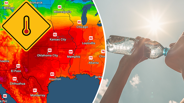
The TemperatureRadar still shows warmer-than-average temperatures for the East and cooler-than-average temperatures for the West. The Northeast will see highs in the 70s and 80s, while 80s and 90s are in play across much of the South, Plains, and Midwest. The West Coast, northern California and the Pacific Northwest will see highs in the 60s.

Tropical update:

There are three areas of interest we are watching today. The remnants of Gordon have a medium chance of redeveloping later this week in the central Atlantic. There's also the chance that another wave in the central Atlantic could see tropical development. What we are paying the closest attention to is the Caribbean where a tropical depression could form by next week.

The news we're covering today:

  • Cool West, above-average East
  • Storms for the Midwest

Did you miss these?

Auroras across the Northern U.S.read more
Extreme heat for South Floridaread more

App news & updates:

Hurricane season doesn't end until Nov. 30 in the Atlantic. Are your hurricane alerts on? Check here.

Mary Mays
This might also interest you
Friday daily briefing for December 26th
Friday, December 26, 2025

Daily briefing

Icy mess hits Mid-Atlantic
Feliz navidad
Thursday, December 25, 2025

Message from us

Merry Christmas!
Split image of freezing rain turned to ice over street lamps and infographic describing the different precipitation types.
Friday, December 26, 2025

Snow, sleet, graupel...

The different winter precipitation types
All articles
Weather & Radar

Weather & Radar is also available on

Google Play StoreApp Store

Company

Contact us Privacy policy Legal info Accessibility statement

Services

Uploader

Socials

instagramfacebookthreadslinkList