Home
Weather New York
WeatherRadar
RainRadar
TemperatureRadar
WindRadar
LightningRadar
Weather News
Editor's Pick
Discover the app
Weather widget
Contact us
Apps
Career
    Home / Weather News /

    Heatwave shifts - Taste of autumn on the way

06:58 PM
August 28, 2026

Heatwave shifts
Taste of autumn on the way

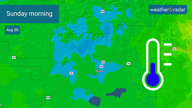
Sunday morning lows in eastern Oregon could hit the freezing mark.

It's been a while since we've seen record cold pop up in the forecast, as average and above-average warmth have dominated thermometers. A shift in high pressure allows for cooler temperatures to make their way in, and it's closer than we think!

Many have been dealing with triple-digit heat across the southern U.S. over the last few weeks. The high-pressure ridge is going to make a slight shift, sharing the record-breaking heat with the East Coast. While the South continues to roast, this slight shift makes room for record-breaking cooler air to enter the Northwest as early as Sunday.

Deep blue hues can be seen on the TemperatureRadar for this weekend, with Burns, Ore., possibly breaking a low temperature record of 31°F from 1999 Sunday morning. Time to get out the big coats!

Becca Parker
More on the topic
How does fog form?. Multiple ways. . . Saturday, July 11, 2026
Saturday, July 11, 2026

Multiple ways

How does fog form?
Super Typhoon Bavi threatens Taiwan. 155 mph winds. . Weather Videos. Wednesday, July 8, 2026
The image shows an intense tropical cyclone over the western Pacific, east of Taiwan and the Philippines. The centre of the system is depicted as a light purple and white vortex with a clearly visible eye, surrounded by a ring of red and orange areas indicating the strongest wind speeds. A white arrow marks the typhoon’s predicted track towards the north-west, in the direction of Taiwan. To the west of the storm lie the Philippines, with the cities of Manila and Cebu; to the north of these lies Taiwan, with Taipei. Further west, the Chinese coast, including Hong Kong, and parts of Vietnam can be seen. The coloured wind map shows predominantly green areas outside the storm’s core, indicating significantly weaker winds. White streamlines illustrate the typhoon’s anti-clockwise circulation in the Northern Hemisphere. The highest wind speeds are concentrated around the eye of the cyclone.
Weather VideosWednesday, July 8, 2026

155 mph winds

Super Typhoon Bavi threatens Taiwan
The best views of Wednesday's eclipse. Europe's sky show. . . Thursday, August 13, 2026
Solar eclipse: The sun obscured between wind turbines in Sardinia
Thursday, August 13, 2026

Europe's sky show

The best views of Wednesday's eclipse
All weather news
This might also interest you
20 days of at least 100°F. Southern Plains. . . Thursday, August 20, 2026
Thursday, August 20, 2026

Southern Plains

20 days of at least 100°F
100 days of at least 100°F. Phoenix. . . Wednesday, August 26, 2026
Wednesday, August 26, 2026

Phoenix

100 days of at least 100°F
Atlantic springs into activity. Tropical Storm Dolly. . . Thursday, August 27, 2026
Thursday, August 27, 2026

Tropical Storm Dolly

Atlantic springs into activity
All articles
Weather & Radar

Weather & Radar is also available on

Google Play StoreApp Store

Company

Contact us Privacy policy Legal info Accessibility statement

Services

Uploader

Socials

instagramfacebookthreadslinkList