Home
Weather New York
WeatherRadar
RainRadar
TemperatureRadar
WindRadar
LightningRadar
Weather News
Editor's Pick
Discover the app
Weather widget
Contact us
Apps
Career
    Home / Weather News /

    Big Texas changes! is it fall yet, for everyone?

03:12 PM
October 16, 2024

Trade heat for fire risk
Big Texas changes! Is it fall yet, for everyone?

We know most of Texas felt the heat yesterday, but that is changing with the cold front that has just pushed through! Are you ready?

Austin reached 99 degrees, San Antonio 95, Del Rio 96, Houston 98, Corpus Christi 95, and the Brownsville area in extreme southern Texas reached 91 degrees. Northern Texas was not too far from the south half, with the Dallas-Fort Worth area reaching 93 degrees, and even Lubbock reached 91 degrees on Tuesday. Temperatures on Wednesday afternoon will be below average for this time of the year, with some areas like western Texas about 30 degrees lower than Tuesday afternoon.

The perfect fire reciperead more

The fire risk will increase with cooler and drier air moving in and the incoming high-pressure system that will set up camp behind it. It will be breezy and windy, and these strong winds could propagate any fires that get started. Make sure to avoid fires and anything that could ignite them, such as throwing cigarette butts out the window or parking over dry vegetation where the tail pipe of your car could ignite the vegetation and start a fire.

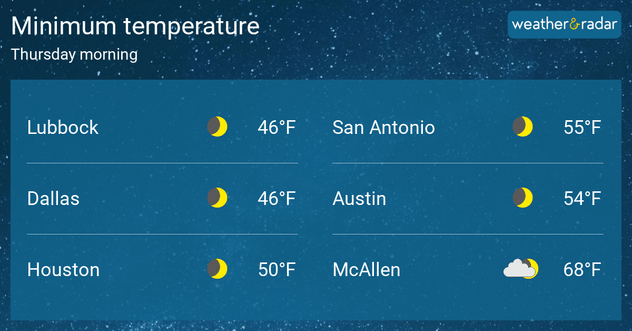
Tonight into Thursday morning will be the coldest night for much of Texas. Lows will drop to the mid-to-upper 40s across Southeast Texas, with lows in the low-50s closer to the coast. Forties will be the norm all the way north to northern Texas and between the upper-40s and low-50s across South-Central Texas. These temps, in true Texas fashion, especially for this time of the year, will not last too long. There will be a warming trend, but staying around normal values through the weekend.

Irene Sans
More on the topic
Hawaii's second 2026 hurricane impact. Hurricane Lowell. . . Tuesday, September 8, 2026
Tuesday, September 8, 2026

Hurricane Lowell

Hawaii's second 2026 hurricane impact
Hurricane Polo remains dangerous. Active Pacific. . . Thursday, September 24, 2026
Thursday, September 24, 2026

Active Pacific

Hurricane Polo remains dangerous
How does fog form?. Multiple ways. . . Saturday, September 12, 2026
Saturday, September 12, 2026

Multiple ways

How does fog form?
All weather news
This might also interest you
30-degree drop on heels of equinox. Mid-Atlantic & Southeast. . . Monday, September 21, 2026
Monday, September 21, 2026

Mid-Atlantic & Southeast

30-degree drop on heels of equinox
High winds whip East Coast. Nor'easter spins offshore. . . Friday, September 25, 2026
Friday, September 25, 2026

Nor'easter spins offshore

High winds whip East Coast
Double September's rain in 72 hours. New Mexico. . . Tuesday, September 22, 2026
Tuesday, September 22, 2026

New Mexico

Double September's rain in 72 hours
All articles
Weather & Radar

Weather & Radar is also available on

Google Play StoreApp Store

Company

Contact us Privacy policy Legal info Accessibility statement

Services

Uploader

Socials

instagramfacebookthreadslinkList