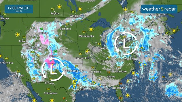
Home / Weather News /

Breakfast Brief - Blocking pattern brings dangerous rain

08:00 AM
May 6, 2025

Breakfast Brief
Blocking pattern brings dangerous rain

Active weather continues across the southern Plains and into the central Gulf Coast as a blocking pattern brings rounds of rain. Severe storms and flash flooding are concerns. The Breakfast Brief is published Monday through Friday at 5:00 a.m. Eastern Time.

A blocking pattern is in place, with two low-pressure systems bringing more wet weather to the Plains and Northeast. This is called an "omega block" and will bring the threat of flash flooding to parts of the South today.

Rain and storms around two low pressure systems.

The WeatherRadar shows showers and storms firing up across the southern Plains, with heavy downpours expected from the Rockies to the central Gulf Coast. A severe threat is in place for central Texas. Damaging wind, hail and isolated tornadoes are possible in cities like Waco, Dallas, Houston and Austin, Texas. A few isolated strong storms may develop from Rochester, N.Y., to Scranton, Penn.

Flash flooding is a significant concern today across the central Gulf Coast, where 5 to 7 inches of rain are expected through tomorrow morning. Remember to turn around, don't drown, if waters rise on the road.

Today, above-average temperatures will prevail across the Pacific Northwest and Upper Midwest. Areas socked in with rain, including the Rockies, the southern Plains and the Ohio River Valley, will remain cooler than average.

News we're covering today

  • Severe storms target central Texas.
  • Significant flood threat for the central Gulf Coast.

Things you may have missed

Severe storms for South Floridaread more
Learn about dust devilsread more

App news

When severe weather is in your forecast, you can be prepared. Follow along with these tools to stay weather-aware.

Mary Mays
More on the topic
Man sits with telescope looking up at the Milky Way.
Sunday, September 7, 2025

September astro outlook

Equinox dominates the month
Time change  Fall back
Saturday, November 1, 2025

Time change

Adding an hour this weekend
storm surge sandy
Saturday, September 27, 2025

The deadliest threat

How to stay safe from storm surge
All weather news
This might also interest you
Wednesday, October 29, 2025

Autumn arrives

Florida chills out
Hurricane Melissa is an intense Category 5 storm with sustained winds of 185 mph, making it one of the most intense on record. Jamaica is bracing for torrential rain, hurricane-force winds, dangerous landslides and life-threatening storm surge.
Tuesday, October 28, 2025

All eyes on Jamaica

Tracking intense Hurricane Melissa
Sunday, October 26, 2025

Jamaica, Cuba in path

Hurricane Melissa rapidly intensifies, catastrophic impacts
All articles
Weather & Radar

www.weatherandradar.com

instagramfacebookthreadsContact uslinkList
Privacy policy | Legal info | Accessibility statement