Home
Weather New York
WeatherRadar
RainRadar
TemperatureRadar
WindRadar
LightningRadar
Weather News
Editor's Pick
Discover the app
Weather widget
Contact us
Apps
Career
    Home / Weather News /

    Breakfast brief - Frigid but calm Friday

10:00 AM
February 21, 2025

Breakfast brief
Frigid but calm Friday

After a busy week of heavy snow, downpours and a few flooding spots, the work week ends on a much quieter, albeit cold, note. The Breakfast Brief is published daily, Monday through Friday, at 5:00 a.m., Eastern time.

The big story continues about an Arctic blast that settled across the central, southern, and eastern U.S. The TemperatureRadar shows a sub-freezing start as far south as Houston and Jacksonville, Fla., with sub-zero temperatures across the central Plains. Highs will only get into the 40s across Texas, the South and Southeast, while much of the Plains, Midwest, and Northeast stays in the 20s and low 30s.

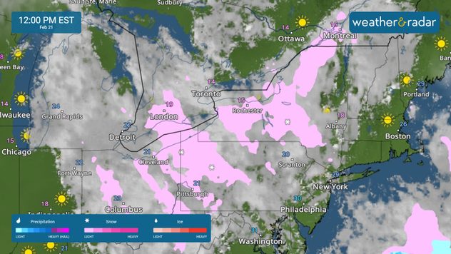
In addition to the cold weather, the WeatherRadar shows lingering lake-effect snow hitting upstate New York and northwestern Pennsylvania. With the arctic temperatures in place, slick roads are likely.

The Northwest will experience a few showers and downpours later today. The Southwest, California, and the Mountain West will be mostly sunny. The Southwest and southern California will be in the 70s, with the 60s found across northern and central California. The rest of the West will be in the 40s and 50s.

News we're covering

  • Weekend preview
  • Deep freeze

Things you might have missed

Coastal snowread more
Long lake-effect seasonread more

James West
More on the topic
How does fog form?. Multiple ways. . . Saturday, July 11, 2026
Saturday, July 11, 2026

Multiple ways

How does fog form?
Super Typhoon Near the Philippines. Gusts up to 155. . . Tuesday, June 23, 2026
Tuesday, June 23, 2026

Gusts up to 155

Super Typhoon Near the Philippines
Super Typhoon Bavi threatens Taiwan. 155 mph winds. . Weather Videos. Wednesday, July 8, 2026
The image shows an intense tropical cyclone over the western Pacific, east of Taiwan and the Philippines. The centre of the system is depicted as a light purple and white vortex with a clearly visible eye, surrounded by a ring of red and orange areas indicating the strongest wind speeds. A white arrow marks the typhoon’s predicted track towards the north-west, in the direction of Taiwan. To the west of the storm lie the Philippines, with the cities of Manila and Cebu; to the north of these lies Taiwan, with Taipei. Further west, the Chinese coast, including Hong Kong, and parts of Vietnam can be seen. The coloured wind map shows predominantly green areas outside the storm’s core, indicating significantly weaker winds. White streamlines illustrate the typhoon’s anti-clockwise circulation in the Northern Hemisphere. The highest wind speeds are concentrated around the eye of the cyclone.
Weather VideosWednesday, July 8, 2026

155 mph winds

Super Typhoon Bavi threatens Taiwan
All weather news
This might also interest you
Rare hurricane impacts possible. Big Island, Hawaii. . . Thursday, August 13, 2026
Thursday, August 13, 2026

Big Island, Hawaii

Rare hurricane impacts possible
6 riskiest places to live: hurricane edition. Do you live there?. . . Sunday, August 16, 2026
Hurricane Irma covers the entiret of Florida with Hurricane Maria coming up behind it.
Sunday, August 16, 2026

Do you live there?

6 riskiest places to live: hurricane edition
Downbursts: Why are they dangerous?. Torrential downpour. . . Saturday, August 15, 2026
Downburst shown on the WeatherRadar.
Saturday, August 15, 2026

Torrential downpour

Downbursts: Why are they dangerous?
All articles
Weather & Radar

Weather & Radar is also available on

Google Play StoreApp Store

Company

Contact us Privacy policy Legal info Accessibility statement

Services

Uploader

Socials

instagramfacebookthreadslinkList