Home
Weather New York
WeatherRadar
RainRadar
TemperatureRadar
WindRadar
LightningRadar
Weather News
Editor's Pick
Discover the app
Weather widget
Contact us
Apps
Career
    Home / Weather News /

    Breakfast brief: Late season snow for the Northeast

09:00 AM
April 4, 2024

Breakfast brief
Late season snow for the Northeast

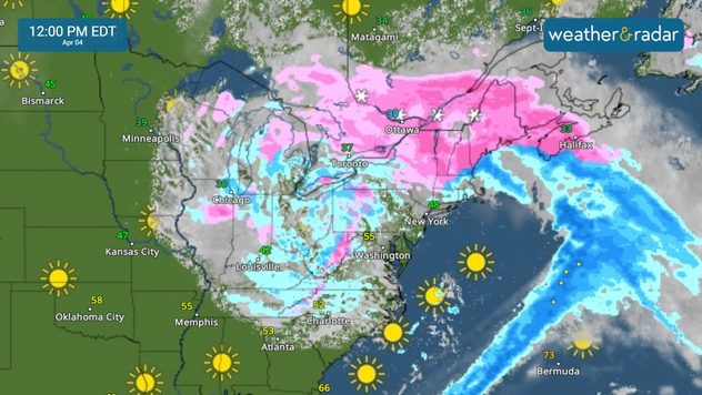
A powerful Spring storm that brought severe weather chances earlier in the week will help bring wintry weather to the Northeast. In the West, a Pacific storm brings rain and mountain snow.

Need a reminder?

April showers bring May flowers! Those under umbrellas that past several days can look forward to more spring blooms soon!

Today's weather outlook

The spring storm system that brought severe storms earlier in the week is still going. While the severe weather threat has diminished, heavy snow is expected on the cold side of this system. Snow will continue to fall in the Midwest, with snow showers pushing south and east into the Appalachians and New England. Onshore winds may lead to coastal flooding in the Northeast.

Northeast snow

The West Coast is being hit with coastal rain and mountain snow as a new system continues to move inland. This moisture will move into the Great Basin later in the day and into Friday.

News we're covering today:

  • Late-season snow for the Midwest, Northeast
  • Rain and mountain snow for the West Coast

Did you miss these?

Strong quake hits Taiwanread more
Cloud cover and the eclipseread more

Are you joining us?

Mark your calendars! We're just days away from the biggest astronomical event of the year - the April 8th Total Solar Eclipse! Tap below to watch the live feed with us!

More on the topic
How does fog form?. Multiple ways. . . Saturday, July 11, 2026
Saturday, July 11, 2026

Multiple ways

How does fog form?
Super Typhoon Near the Philippines. Gusts up to 155. . . Tuesday, June 23, 2026
Tuesday, June 23, 2026

Gusts up to 155

Super Typhoon Near the Philippines
Super Typhoon Bavi threatens Taiwan. 155 mph winds. . Weather Videos. Wednesday, July 8, 2026
The image shows an intense tropical cyclone over the western Pacific, east of Taiwan and the Philippines. The centre of the system is depicted as a light purple and white vortex with a clearly visible eye, surrounded by a ring of red and orange areas indicating the strongest wind speeds. A white arrow marks the typhoon’s predicted track towards the north-west, in the direction of Taiwan. To the west of the storm lie the Philippines, with the cities of Manila and Cebu; to the north of these lies Taiwan, with Taipei. Further west, the Chinese coast, including Hong Kong, and parts of Vietnam can be seen. The coloured wind map shows predominantly green areas outside the storm’s core, indicating significantly weaker winds. White streamlines illustrate the typhoon’s anti-clockwise circulation in the Northern Hemisphere. The highest wind speeds are concentrated around the eye of the cyclone.
Weather VideosWednesday, July 8, 2026

155 mph winds

Super Typhoon Bavi threatens Taiwan
All weather news
This might also interest you
Lala poses rare hurricane landfall. Hawaiian Islands. . . Friday, August 14, 2026
Lala is set to become a hurrricane with a possible record-making landfall on the Big Island in Hawaii.
Friday, August 14, 2026

Hawaiian Islands

Lala poses rare hurricane landfall
Downbursts: Why are they dangerous?. Torrential downpour. . . Saturday, August 15, 2026
Downburst shown on the WeatherRadar.
Saturday, August 15, 2026

Torrential downpour

Downbursts: Why are they dangerous?
Temperatures rise 20 degrees at 2 am?. What is a heat burst?. . . Sunday, August 16, 2026
Heat burst in Nebraska
Sunday, August 16, 2026

What is a heat burst?

Temperatures rise 20 degrees at 2 am?
All articles
Weather & Radar

Weather & Radar is also available on

Google Play StoreApp Store

Company

Contact us Privacy policy Legal info Accessibility statement

Services

Uploader

Socials

instagramfacebookthreadslinkList