Home
Weather New York
WeatherRadar
RainRadar
TemperatureRadar
WindRadar
LightningRadar
Weather News
Editor's Pick
Discover the app
Weather widget
Contact us
Apps
Career
    Home / Editor's Pick /

    Breakfast Brief: Northeast storm bring stormy conditions and big East cooldown

09:00 AM
October 14, 2024

Breakfast Brief
Big East cooldown, Northeast storm

A powerful storm system is kicking off the week with turbulent weather, delivering stormy conditions and even an early taste of winter to parts of the Great Lakes and Northeast. Meanwhile, a national mix of summer heat and fall cooldown will be felt across the country.

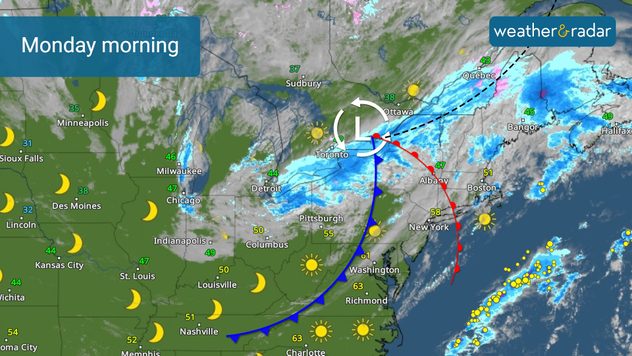
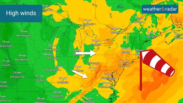
On Monday, a strong autumn storm is sweeping across the lower Great Lakes and into the Northeast, bringing widespread rain and gusty winds. In interior parts of the Northeast, especially in higher elevations and during the cooler overnight hours, some snowflakes are possible. Accumulating snow could occur across the highest peaks of the Adirondacks, Green, and White mountains tonight.

1/2
The WeatherRadar shows isolated pockets of snow in the higher elevations of interior Northeast on Monday, October 14, 2024

Did you know?

On this day in 1981, an unseasonal October snowstorm hit the central and northern Rockies briniging heavy snow and unusually cold temperatures. Up to two feet of snow fell in the higher elevations causing power outages and travel disruptions.

This same system is pushing a potent cold front through the eastern half of the U.S., replacing the unseasonably warm weekend temperatures across the Midwest, Tennessee Valley, and Mid-Atlantic with a sharp drop. Cities like Lexington, Ky., Nashville, Tenn., Charlotte, N.C., Richmond, Va., and Memphis, Tenn. may experience temperature drops of up to 20 degrees by Monday morning. This cooling trend is expected to continue through midweek, extending as far south as the Deep South.

West of the Rockies and in Texas, however, an entirely different story is unfolding. Much above-normal temperatures will persist, with the northern High Plains and Rockies seeing highs in the 80s, well above seasonal norms. In Texas, particularly the eastern part of the state, temperatures are expected to soar close to 100 degrees on Monday.

Tropical update:

In the tropics, a tropical disturbance is moving the the tropical central Atlantic. It could develop into a depression as it approaches the Greater Antilles this week.

News we are covering today:

  • Storm system shifting across the Northeast

Did you miss these?

Once in a lifetime comet in viewread more
Hurricane Milton-A record tornado makerread more
Auroras dazzle the night skyread more

App news & updates:

It's never too early to prepare for the winter season! Is your blizzard kit in order?

Federico Di Catarina
More on the topic
Rip currents & safety tips. As more head to the coast. . . Saturday, July 25, 2026
rip current
Saturday, July 25, 2026

As more head to the coast

Rip currents & safety tips
High pressure & extreme heat. Why & how does it work?. . . Sunday, July 12, 2026
Sunday, July 12, 2026

Why & how does it work?

High pressure & extreme heat
Europe: Warmest June on record. Warm waters too. . . Friday, July 10, 2026
The record-breaking heatwave in June has made climate history in Western Europe.
Friday, July 10, 2026

Warm waters too

Europe: Warmest June on record
All weather news
This might also interest you
Lopsided Bertha moves west. Who sees the impacts. . . Thursday, July 23, 2026
Thursday, July 23, 2026

Who sees the impacts

Lopsided Bertha moves west
Temps 15-degrees below average. Big cold front. . . Wednesday, July 22, 2026
Wednesday, July 22, 2026

Big cold front

Temps 15-degrees below average
Multi-day rain event ends soon. Southeast U.S.. . . Friday, July 24, 2026
Friday, July 24, 2026

Southeast U.S.

Multi-day rain event ends soon
All articles
Weather & Radar

Weather & Radar is also available on

Google Play StoreApp Store

Company

Contact us Privacy policy Legal info Accessibility statement

Services

Uploader

Socials

instagramfacebookthreadslinkList